Earthquakes
USGS
| MAG | UTC DATE-TIME y/m/d h:m:s |
LAT deg |
LON deg |
DEPTH km |
Region | |
|---|---|---|---|---|---|---|
| MAP | 2.6 | 2012/10/31 22:48:46 | 36.048 | -117.515 | 1.9 | CENTRAL CALIFORNIA |
| MAP | 4.6 | 2012/10/31 22:46:31 | 52.273 | -171.545 | 62.3 | FOX ISLANDS, ALEUTIAN ISLANDS, ALASKA |
| MAP | 4.8 | 2012/10/31 21:27:05 | -4.620 | 153.369 | 43.0 | NEW IRELAND REGION, PAPUA NEW GUINEA |
| MAP | 3.2 | 2012/10/31 19:10:06 | 19.592 | -65.278 | 17.0 | PUERTO RICO REGION |
| MAP | 3.1 | 2012/10/31 16:40:13 | 18.288 | -65.470 | 13.0 | PUERTO RICO REGION |
| MAP | 4.7 | 2012/10/31 16:26:38 | -30.157 | -177.791 | 61.0 | KERMADEC ISLANDS, NEW ZEALAND |
| MAP | 3.2 | 2012/10/31 15:29:53 | 40.974 | -123.700 | 12.6 | NORTHERN CALIFORNIA |
| MAP | 2.7 | 2012/10/31 15:19:42 | 19.387 | -155.249 | 3.5 | ISLAND OF HAWAII, HAWAII |
| MAP | 4.6 | 2012/10/31 15:15:07 | -5.333 | 34.833 | 10.0 | TANZANIA |
| MAP | 2.8 | 2012/10/31 14:21:04 | 53.569 | -164.854 | 29.8 | UNIMAK ISLAND REGION, ALASKA |
| MAP | 4.2 | 2012/10/31 13:00:15 | 41.792 | -127.083 | 10.0 | OFF THE COAST OF NORTHERN CALIFORNIA |
| MAP | 4.5 | 2012/10/31 12:35:13 | -18.645 | -177.530 | 315.9 | FIJI REGION |
| MAP | 2.5 | 2012/10/31 12:05:59 | 36.087 | -89.772 | 6.3 | SOUTHEASTERN MISSOURI |
| MAP | 3.2 | 2012/10/31 09:52:58 | 37.088 | -121.503 | 8.1 | NORTHERN CALIFORNIA |
| MAP | 4.9 | 2012/10/31 06:53:56 | -2.048 | 99.713 | 21.3 | KEPULAUAN MENTAWAI REGION, INDONESIA |
| MAP | 4.5 | 2012/10/31 06:50:02 | 36.014 | 139.837 | 46.9 | EASTERN HONSHU, JAPAN |
| MAP | 4.0 | 2012/10/31 02:57:43 | 62.045 | -146.545 | 40.7 | CENTRAL ALASKA |
| MAG | UTC DATE-TIME y/m/d h:m:s |
LAT deg |
LON deg |
DEPTH km |
Region | |
|---|---|---|---|---|---|---|
| MAP | 3.2 | 2012/10/30 23:26:16 | 58.955 | -154.355 | 122.7 | ALASKA PENINSULA |
| MAP | 2.5 | 2012/10/30 23:19:10 | 19.403 | -155.296 | 3.3 | ISLAND OF HAWAII, HAWAII |
| MAP | 2.9 | 2012/10/30 23:02:19 | 61.432 | -150.725 | 63.3 | SOUTHERN ALASKA |
| MAP | 4.5 | 2012/10/30 22:49:52 | 2.127 | 127.035 | 88.5 | MOLUCCA SEA |
| MAP | 2.8 | 2012/10/30 22:23:36 | 61.439 | -150.695 | 66.5 | SOUTHERN ALASKA |
| MAP | 4.2 | 2012/10/30 22:02:46 | 61.496 | -150.723 | 67.4 | SOUTHERN ALASKA |
| MAP | 2.7 | 2012/10/30 21:16:17 | 34.238 | -116.811 | 8.2 | SOUTHERN CALIFORNIA |
| MAP | 3.2 | 2012/10/30 18:04:35 | 61.618 | -140.669 | 16.5 | SOUTHERN YUKON TERRITORY, CANADA |
| MAP | 2.5 | 2012/10/30 17:43:02 | 34.774 | -118.282 | 0.0 | SOUTHERN CALIFORNIA |
| MAP | 2.5 | 2012/10/30 17:35:54 | 33.377 | -116.848 | 7.0 | SOUTHERN CALIFORNIA |
| MAP | 4.0 | 2012/10/30 17:33:30 | 52.568 | -132.312 | 1.1 | QUEEN CHARLOTTE ISLANDS REGION |
| MAP | 2.7 | 2012/10/30 17:25:59 | 37.499 | -118.534 | 14.5 | CENTRAL CALIFORNIA |
| MAP | 4.5 | 2012/10/30 16:56:49 | 14.458 | 146.827 | 40.7 | ROTA REGION, NORTHERN MARIANA ISLANDS |
| MAP | 4.6 | 2012/10/30 15:22:53 | -17.979 | -178.566 | 623.1 | FIJI REGION |
| MAP | 4.6 | 2012/10/30 14:10:59 | 52.285 | -131.948 | 10.0 | QUEEN CHARLOTTE ISLANDS REGION |
| MAP | 2.6 | 2012/10/30 13:45:10 | 59.787 | -152.482 | 65.7 | SOUTHERN ALASKA |
| MAP | 5.2 | 2012/10/30 13:12:29 | -37.949 | 177.681 | 67.8 | OFF EAST COAST OF THE NORTH ISLAND, N.Z. |
| MAP | 2.8 | 2012/10/30 13:12:29 | 59.863 | -154.185 | 199.2 | SOUTHERN ALASKA |
| MAP | 4.6 | 2012/10/30 12:53:40 | 12.554 | -87.961 | 87.8 | NEAR THE COAST OF NICARAGUA |
| MAP | 4.7 | 2012/10/30 12:53:05 | -24.742 | -179.616 | 541.2 | SOUTH OF THE FIJI ISLANDS |
| MAP | 4.4 | 2012/10/30 12:18:20 | 6.836 | -73.056 | 148.2 | NORTHERN COLOMBIA |
| MAP | 4.7 | 2012/10/30 11:43:55 | -5.341 | 102.728 | 41.9 | SOUTHERN SUMATRA, INDONESIA |
| MAP | 5.1 | 2012/10/30 10:59:33 | -18.219 | -174.809 | 9.8 | TONGA |
| MAP | 4.5 | 2012/10/30 10:11:41 | 53.391 | 108.066 | 17.9 | LAKE BAYKAL REGION, RUSSIA |
| MAP | 2.9 | 2012/10/30 10:02:51 | 63.087 | -151.604 | 15.0 | CENTRAL ALASKA |
| MAP | 2.6 | 2012/10/30 09:40:47 | 18.791 | -64.495 | 41.0 | VIRGIN ISLANDS REGION |
| MAP | 2.6 | 2012/10/30 09:01:59 | 52.901 | -163.745 | 23.3 | SOUTH OF ALASKA |
| MAP | 4.4 | 2012/10/30 08:44:21 | 2.739 | 128.664 | 224.5 | HALMAHERA, INDONESIA |
| MAP | 4.2 | 2012/10/30 08:09:27 | 36.662 | 26.508 | 157.0 | DODECANESE ISLANDS, GREECE |
| MAP | 2.9 | 2012/10/30 08:01:00 | 36.604 | -121.212 | 8.7 | CENTRAL CALIFORNIA |
| MAP | 3.1 | 2012/10/30 07:57:39 | 19.558 | -65.271 | 7.0 | PUERTO RICO REGION |
| MAP | 3.3 | 2012/10/30 07:45:31 | 19.406 | -65.276 | 57.0 | PUERTO RICO REGION |
| MAP | 3.2 | 2012/10/30 07:35:00 | 19.248 | -64.115 | 93.0 | VIRGIN ISLANDS REGION |
| MAP | 2.6 | 2012/10/30 07:29:00 | 34.657 | -121.306 | 11.3 | OFFSHORE CENTRAL CALIFORNIA |
| MAP | 4.9 | 2012/10/30 07:12:35 | -17.917 | -178.592 | 560.7 | FIJI REGION |
| MAP | 5.2 | 2012/10/30 07:12:30 | -4.615 | 151.864 | 156.7 | NEW BRITAIN REGION, PAPUA NEW GUINEA |
| MAP | 2.7 | 2012/10/30 06:30:19 | 60.637 | -151.155 | 18.8 | KENAI PENINSULA, ALASKA |
| MAP | 2.7 | 2012/10/30 06:09:19 | 36.459 | -121.038 | 6.5 | CENTRAL CALIFORNIA |
| MAP | 2.9 | 2012/10/30 05:50:13 | 62.832 | -149.513 | 0.0 | CENTRAL ALASKA |
| MAP | 4.4 | 2012/10/30 05:22:17 | -23.001 | -69.708 | 75.7 | ANTOFAGASTA, CHILE |
| MAP | 4.7 | 2012/10/30 04:40:15 | 52.170 | -131.604 | 10.2 | QUEEN CHARLOTTE ISLANDS REGION |
| MAP | 2.9 | 2012/10/30 03:07:44 | 19.084 | -65.145 | 33.0 | VIRGIN ISLANDS REGION |
| MAP | 2.6 | 2012/10/30 02:58:31 | 19.401 | -155.258 | 2.1 | ISLAND OF HAWAII, HAWAII |
| MAP | 5.0 | 2012/10/30 02:55:15 | 52.484 | -131.486 | 5.1 | QUEEN CHARLOTTE ISLANDS REGION |
| MAP | 6.2 | 2012/10/30 02:49:03 | 52.324 | -131.908 | 9.7 | QUEEN CHARLOTTE ISLANDS REGION |
| MAP | 4.3 | 2012/10/30 02:17:33 | 36.362 | 70.802 | 185.3 | HINDU KUSH REGION, AFGHANISTAN |
| MAP | 4.6 | 2012/10/30 00:41:34 | -36.203 | -100.250 | 10.0 | SOUTHEAST OF EASTER ISLAND |
| MAP | 4.1 | 2012/10/30 00:35:10 | 52.412 | -131.645 | 10.0 | QUEEN CHARLOTTE ISLANDS REGION |
| MAP | 2.5 | 2012/10/30 00:34:17 | 33.880 | -115.996 | 0.8 | SOUTHERN CALIFORNIA |
| MAP | 4.0 | 2012/10/30 00:32:18 | 52.467 | -132.126 | 10.4 | QUEEN CHARLOTTE ISLANDS REGION |
| MAG | UTC DATE-TIME y/m/d h:m:s |
LAT deg |
LON deg |
DEPTH km |
Region | |
|---|---|---|---|---|---|---|
| MAP | 4.7 | 2012/10/29 23:51:42 | -8.176 | 123.412 | 19.6 | FLORES REGION, INDONESIA |
| MAP | 4.7 | 2012/10/29 23:40:17 | -8.163 | 123.453 | 9.1 | FLORES REGION, INDONESIA |
| MAP | 4.7 | 2012/10/29 22:41:13 | -15.263 | -172.934 | 34.2 | SAMOA ISLANDS REGION |
| MAP | 2.9 | 2012/10/29 22:23:42 | 62.159 | -148.814 | 20.5 | CENTRAL ALASKA |
| MAP | 4.3 | 2012/10/29 22:00:33 | 52.616 | -132.260 | 10.3 | QUEEN CHARLOTTE ISLANDS REGION |
| MAP | 3.0 | 2012/10/29 22:00:17 | 61.565 | -140.683 | 15.6 | SOUTHERN YUKON TERRITORY, CANADA |
| MAP | 2.5 | 2012/10/29 21:52:17 | 61.317 | -141.645 | 17.4 | SOUTHERN ALASKA |
| MAP | 4.3 | 2012/10/29 21:46:58 | 3.253 | 121.881 | 604.5 | CELEBES SEA |
| MAP | 3.9 | 2012/10/29 21:41:33 | 61.455 | -141.129 | 10.0 | SOUTHERN ALASKA |
| MAP | 4.9 | 2012/10/29 21:20:36 | -4.752 | 153.162 | 81.7 | NEW IRELAND REGION, PAPUA NEW GUINEA |
| MAP | 2.5 | 2012/10/29 21:06:07 | 61.422 | -141.146 | 10.0 | SOUTHERN ALASKA |
| MAP | 4.6 | 2012/10/29 20:49:49 | 52.366 | -131.459 | 26.6 | QUEEN CHARLOTTE ISLANDS REGION |
| MAP | 3.0 | 2012/10/29 20:10:40 | 32.182 | -115.187 | 0.1 | BAJA CALIFORNIA, MEXICO |
| MAP | 5.1 | 2012/10/29 19:49:06 | -0.452 | 132.742 | 28.9 | NEAR THE NORTH COAST OF PAPUA, INDONESIA |
| MAP | 2.8 | 2012/10/29 19:28:58 | 19.400 | -155.258 | 2.4 | ISLAND OF HAWAII, HAWAII |
| MAP | 4.1 | 2012/10/29 16:33:09 | 52.231 | -131.964 | 10.0 | QUEEN CHARLOTTE ISLANDS REGION |
| MAP | 2.8 | 2012/10/29 15:55:46 | 19.360 | -154.965 | 38.6 | HAWAII REGION, HAWAII |
| MAP | 4.0 | 2012/10/29 15:38:30 | 52.074 | -132.137 | 10.0 | QUEEN CHARLOTTE ISLANDS REGION |
| MAP | 5.7 | 2012/10/29 15:29:53 | -0.155 | 125.245 | 62.3 | MOLUCCA SEA |
| MAP | 4.0 | 2012/10/29 15:15:02 | 51.989 | -132.225 | 10.0 | QUEEN CHARLOTTE ISLANDS REGION |
| MAP | 4.0 | 2012/10/29 15:01:07 | 52.013 | -131.757 | 10.0 | QUEEN CHARLOTTE ISLANDS REGION |
| MAP | 4.9 | 2012/10/29 14:54:53 | 80.651 | -3.355 | 10.0 | NORTH OF SVALBARD |
| MAP | 4.8 | 2012/10/29 14:35:14 | 12.104 | -88.260 | 35.0 | NEAR THE COAST OF NICARAGUA |
| MAP | 4.4 | 2012/10/29 14:22:50 | -37.675 | -73.894 | 13.7 | OFFSHORE BIO-BIO, CHILE |
| MAP | 2.5 | 2012/10/29 12:47:36 | 19.427 | -155.276 | 1.7 | ISLAND OF HAWAII, HAWAII |
| MAP | 3.9 | 2012/10/29 12:39:24 | 35.205 | -90.636 | 23.1 | ARKANSAS |
| MAP | 4.4 | 2012/10/29 12:05:15 | 52.574 | -132.552 | 10.2 | QUEEN CHARLOTTE ISLANDS REGION |
| MAP | 2.9 | 2012/10/29 11:49:05 | 35.611 | -81.999 | 6.1 | NORTH CAROLINA |
| MAP | 4.8 | 2012/10/29 10:30:44 | -24.600 | 179.264 | 526.6 | SOUTH OF THE FIJI ISLANDS |
| MAP | 3.4 | 2012/10/29 07:50:54 | 33.389 | -109.237 | 4.8 | ARIZONA |
| MAP | 5.2 | 2012/10/29 06:28:33 | -8.169 | 123.431 | 9.7 | FLORES REGION, INDONESIA |
| MAP | 4.1 | 2012/10/29 06:03:54 | 52.921 | -132.341 | 14.3 | QUEEN CHARLOTTE ISLANDS REGION |
| MAP | 2.7 | 2012/10/29 05:48:42 | 38.816 | -122.780 | 2.2 | NORTHERN CALIFORNIA |
| MAP | 4.5 | 2012/10/29 04:59:36 | 13.303 | -89.516 | 68.2 | OFFSHORE EL SALVADOR |
| MAP | 3.9 | 2012/10/29 04:25:16 | 36.592 | -121.201 | 9.0 | CENTRAL CALIFORNIA |
| MAP | 4.1 | 2012/10/29 03:47:55 | 52.387 | -132.351 | 10.0 | QUEEN CHARLOTTE ISLANDS REGION |
| MAP | 4.0 | 2012/10/29 02:40:53 | 52.411 | -132.465 | 10.0 | QUEEN CHARLOTTE ISLANDS REGION |
| MAP | 5.3 | 2012/10/29 02:22:44 | 0.922 | 98.432 | 54.5 | NIAS REGION, INDONESIA |
| MAP | 4.6 | 2012/10/29 01:49:02 | 52.491 | -131.953 | 10.3 | QUEEN CHARLOTTE ISLANDS REGION |
| MAP | 3.7 | 2012/10/29 01:40:37 | 67.623 | -162.719 | 17.1 | NORTHERN ALASKA |
| MAP | 3.2 | 2012/10/29 00:30:23 | 58.864 | -137.615 | 14.1 | SOUTHEASTERN ALASKA |
| MAP | 4.3 | 2012/10/29 00:26:50 | 52.306 | -132.130 | 10.1 | QUEEN CHARLOTTE ISLANDS REGION |
| MAP | 4.1 | 2012/10/29 00:18:51 | 52.637 | -130.987 | 10.0 | HECATE STRAIT REGION, CANADA |
…………………………………………….
Second largest earthquake to hit Canada since 1949
Canadian Press
Map locates a violent earthquake measuring 7.7 which jolted British Columbia’s north-central coast Saturday night, frightening residents and forcing many to temporarily leave their homes for higher ground ahead of a possible tsunami.
Photograph by: Sean Vokey , Canadian Press
VANCOUVER — The Haida Gwaii region continues to feel the aftershocks of a violent earthquake measuring 7.7 that jolted British Columbia’s north-central coast Saturday night, frightening residents and forcing many to temporarily leave their homes for higher ground ahead of a possible tsunami.
The largest, a 6.4 magnitude tremor, struck Sunday afternoon, 136 kilometers south of Masset. There have been over 40 aftershocks in the area.
Tsunami warnings were issued for the North Coast Saturday, the Haida Gwaii islands, parts of the central B.C. coast, the coast of Alaska and as far away as Hawaii.
Early Sunday morning the warnings were downgraded to advisory status, meaning evacuations were no longer necessary, and they were cancelled altogether a few hours later.
Residents near the centre of the quake said the violent jolting lasted for up to a minute, but no injuries or major damage had been reported.
Carsten Ginsburg, who lives in the small community of Bella Coola southeast of Prince Rupert, said the quake lasted about 40 seconds.
“It shook everything. The electricity went out, the power lines were swinging all over the place and stuff was falling off the shelves.”
Brent Ward, an earth scientist at Simon Fraser University, said the earthquake was the second largest to hit the country since 1949, when another earthquake was recorded in the same area with a magnitude of 8.1.
“It’s an earthquake in an area that gets a lot of earthquakes,” he said. “It’s a tectonically active area.”
Ward said the area is known as the Queen Charlotte fault, where the earth’s plates slide horizontally across each other in a strike-slip action, similar to what happens along California’s San Andreas fault.
“Stresses build up because of that movement, and every so often we get the release of that stress in the form of an earthquake.”
Ward said he wasn’t surprised the tsunami warning was shortlived because the strike-slip movement along the fault doesn’t generally trigger tsunamis.
“To trigger a tsunami you need to have a vertical movement of the sea floor, and it’s that vertical movement that displaces water and triggers the tsunami,” he said. “Because it’s sliding across each other, you’re not generally moving the water.”
In fact, hours after the earthquake, Dennis Sinnott, who works at the Institute of Ocean Sciences, said the largest wave hit Langara Island, a northern Haida Gwaii island, and measured just 69 centimetres.
The quake also set off emergency sirens across the Pacific on the islands of Hawaii, but even as people were moving to higher ground, the warning was called off.
In Alaska, the wave surge was just 10 centimetres, much smaller than officials had been forecasting.
Kelli Kryzanowski, manager of strategic initiatives Emergency Management B.C., said the initial earthquake occurred at 8:04 p.m. inland on Haida Gwaii and was initially recorded at a magnitude of 7.1 but was quickly upgraded to a magnitude of 7.7.
Kryzanowski said small waves generated by the quake, measured at 28 centimetres and 44 centimetres, also hit the northern tip of Vancouver Island.
“What we’re seeing at this time are relatively small sea-level fluctuations,” she said.
B.C. Justice Minister Shirley Bond said there appeared to be little damage from the quake.
“We’re certainly grateful at this point,” said Bond, who spoke to reporters during a late night conference call. “We’re very grateful for that, but we’ll wait until we can actually see the impact.”
After the quake, Ginsburg said he ran home as quickly as he could to see if there was a tsunami warning.
“Which of course there was,” he added.
Ginsburg owns the Float House Inn on the public wharf in Bella Coola and had about six customers celebrating a birthday party.
They all evacuated to about 35 metres above sea level.
“I’m assuming that it’s OK,” he said laughing. “I’m keeping my fingers crossed.”
Bella Coola resident Barb Cornish, 60, said she considers herself a very calm person.
“But I found it quite unnerving,” she told The Canadian Press.
Cornish lives in a log house and had been told that it’s one of the safest places to be in the event of an earthquake.
But she said it sure didn’t feel safe Saturday night.
“The log house swayed and creaked and my light over my kitchen table was swaying, some chimes went off. I stood up and I could feel the undulations under my feet, to the point where I almost got nauseated.”
Geoff Ray said he has felt a lot of earthquakes, but this was the most powerful quake he’s ever experienced in the 37 years he’s lived on Haida Gwaii.
Ray operates the Breezeway Accommodations bed and breakfast in Queen Charlotte City and said the beams of his building were “visibly shaking quite a lot, there were things falling off shelves.”
“(It was) an exciting experience, there’s no doubt about that.”
Lenore Lawrence, a resident of Queen Charlotte City, said the quake was “definitely scary,” adding she wondered if “this could be the big one.”
She thought the shaking lasted more than a minute.
While several things fell off her mantle and broke, she said damage in her home was minimal.
Residents rushed out of their homes in Tofino when the tsunami sirens sounded, but they were allowed to return about two hours after the quake.
Yvette Drews, a resident of Tofino, said she ran out of her home with her two children and mother in-law and drove to a local school when she heard the community’s tsunami sirens go off.
They were told by police that they could return home.
But while on the way home, Drews said she heard the tsunami sirens go off again.
“Well that just freaked me out, hearing the siren and the voice,” she said.
The quake shook Vancouver Island, the Haida Gwaii area, Prince Rupert, Quesnel and Houston, and was even felt in Metro Vancouver and Alaska.
“It’s a good wake-up call for everyone to make sure they have an earthquake kit and a plan if an earthquake like this hits an area that they live,” said Ward.
Tsunami threat in Hawaii downgraded to advisory
VANCOUVER, British Columbia (AP) — A magnitude 7.7 earthquake struck off the west coast of Canada, but there were no reports of major damage. Residents in parts of British Columbia were evacuated, but the province appeared to escape the biggest quake in Canada since 1949 largely unscathed.
The U.S. Geological Survey said the powerful temblor hit the Queen Charlotte Islands just after 8 p.m. local time Saturday at a depth of about 3 miles (5 kilometers) and was centered 96 miles (155 kilometers) south of Masset, British Columbia. It was felt across a wide area in British Columbia, both on its Pacific islands and on the mainland.
“It looks like the damage and the risk are at a very low level,” said Shirley Bond, British Columbia’s minister responsible for emergency management said. “We’re certainly grateful.”
The National Weather Service issued a tsunami warning for coastal areas of British Columbia, southern Alaska and Hawaii, but later canceled it for the first two and downgraded it to an advisory for Hawaii.
Gerard Fryer, a senior geologist with the Pacific Tsunami Warning Center, said the first waves hitting shore in Hawaii were smaller than expected.
Hawaii Gov. Neil Abercrombie said early Sunday that the Aloha State was lucky to avoid more severe surges after the powerful earthquake struck off the coast of Canada. Abercrombie said beaches and harbors are still closed statewide.
“We’re very, very grateful that we can go home tonight counting our blessings,” Abercrombie said.
The weather service also canceled a tsunami advisory for Oregon, leaving northern California as the only spot in North America still under a tsunami advisory.
Dennis Sinnott of the Canadian Institute of Ocean Science said a 69-centimeter (27 inch) wave was recorded off Langara Island on the northeast tip of Haida Gwaii, formerly called the Queen Charlotte Islands. The islands are home to about 5,000 people, many of them members of the Haida aboriginal group. Another 55 centimeter (21 inch) wave hit Winter Harbour on the northeast coast of Vancouver Island.
“It appears to be settling down,” he said. “It does not mean we won’t get another small wave coming through.”
Canada’s largest earthquake since 1700 was an 8.1 magnitude quake on August 22, 1949 off the coast of British Columbia, according to the Canadian government’s Natural Resources website. It occurred on the Queen Charlotte Fault in what the department called Canada’s equivalent of the San Andreas Fault — the boundary between the Pacific and North American plates that runs underwater along the west coast of the Haida Gwaii.
In 1970 a 7.4 magnitude quake struck south of the Haida Gwaii.
The USGS said the temblor shook the waters around British Columbia and was followed by a 5.8 magnitude aftershock after several minutes. Several other aftershocks were reported.
The quake struck 25 miles (40 kilometers) south of Sandspit, British Columbia, on the Haida Gwaii archipelago. People in coastal areas were advised to move to higher ground.
Urs Thomas, operator of the Golden Spruce hotel in Port Clements said there was no warning before everything began moving inside and outside the hotel. He said it lasted about three minutes.
“It was a pretty good shock,” Thomas, 59, said. “I looked at my boat outside. It was rocking. Everything was moving. My truck was moving.”
After the initial jolt, Thomas began to check the hotel.
“The fixtures and everything were still swinging,” he said. “I had some picture frames coming down.”
Lenore Lawrence, a resident of Queen Charlotte City on the Haida Gwaii, said the quake was “definitely scary,” adding she wondered if “this could be the big one.” She said the shaking lasted more than a minute. While several things fell off her mantle and broke, she said damage in her home was minimal.
Many on the B.C. mainland said the same.
“I was sitting at my desk on my computer and everything just started to move. It was maybe 20 seconds,” said Joan Girbav, manager of Pacific Inn in Prince Rupert, British Columbia. “It’s very scary. I’ve lived here all my life and I’ve never felt that.”
Residents rushed out of their homes in Tofino, British Columbia on Vancouver Island when the tsunami sirens sounded, but they were allowed to return about two hours after the quake.
In Hawaii, the tsunami warning spurred residents to stock up on essentials at gas stations and grocery stores and sent tourists in beachside hotels to higher floors in their buildings. Bus service into Waikiki was cut off an hour before the first waves, and police in downtown Honolulu shut down a Halloween block party. In Kauai, three schools used as evacuation centers quickly filled to capacity.
Fryer said the largest wave in the first 45 minutes of the tsunami was measured in Maui at more than 5 feet (1.5 meters), about 2 feet (60 centimeters) higher than normal sea levels. No major damage was reported.
In Alaska, the wave or surge was recorded at 4 inches (10 centimeters), much smaller than forecast, said Jeremy Zidek, a spokesman for the Alaska Department of Homeland Security and Emergency Management. The quake was felt in Craig and other southeast Alaska communities, but Zidek said there were no immediate reports of damage.
Canada quake triggers Hawaii tsunami scare
- NEW: the largest wave was about 2.5 feet above ambient sea level
- NEW: Tsunami advisory lifted
- Hawaii evacuations are lifted
- The tsunami was caused by a magnitude 7.7 earthquake in western Canada
(CNN) — A tsunami warning for Hawaii, triggered by a powerful earthquake in Canada, proved nothing more than a pre-Halloween scare for thousands of people this weekend.
“The tourists are doing their best Chicken Little impressions,” one CNN iReporter in West Maui, Hawaii, wrote early Sunday.
Sirens announced the tsunami warning across Hawaii on Saturday night, as thousands of revelers packed streets in Honolulu for the annual Hallowbaloo festival and many others in costumes headed to Halloween parties.
Restaurants, clubs and the festival immediately shut down and the parties turned into bumper-to-bumper traffic jams as residents headed to higher ground.
Visions of the devastating quake and tsunami that killed thousands in Japan in March 2011 fueled the fright, but the waves proved to be smaller and less powerful than feared.
While the warning said waves could surge between 3 and 6 feet, the largest wave, measured in Kahului on the island of Maui, was about 2.5 feet above ambient sea level, according to Gerard Fryer, senior geophysicist at the Pacific Tsunami Warning Center.
The evacuation orders for coastal residents and the tsunami warning were canceled by 1 a.m. in Hawaii (7 a.m. ET) and a tsunami advisory was put in its place. That advisory was lifted three hours later.
Honolulu Mayor Peter Carlisle said early Sunday that people who had evacuated could return to their homes. CNN affiliate Hawaii News Now reported that was also the case for coastal residents in various parts of the state.
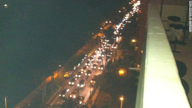
Earlier, local television showed images of bumper-to-bumper traffic on roads leading from the coast to higher ground. About 80,000 people live in evacuation zones on the island of Oahu, where Honolulu is located.
Read the latest developments in our live blog
Even Hawaiians accustomed to tsunami warnings spared no effort in bracing for the worst.
Honolulu resident Victoria Shioi filled her bathtub with water, set her refrigerator to the coldest setting and gathered candles in case of water or power outages.
“Also backed up my computer and put the external (hard drive) in the waterproof safe,” Shioi said.
The tsunami was spawned by a sizable earthquake in western British Columbia, prompting a local tsunami warning.
“A (magnitude) 7.7 is a big, hefty earthquake — not something you can ignore,” Fryer said. “It definitely would have done some damage if it had been under a city.”
Instead, the quake struck about 139 kilometers (86 miles) south of Masset on British Columbia’s Queen Charlotte Islands. No major damage was reported.
The Alaska Tsunami Warning Center issued a warning for western British Columbia from Vancouver to the southern panhandle of Alaska.
Canadians as far away as Prince Rupert, on mainland British Columbia, felt the quake.
Tanya Simonds said she felt as if her house was “sliding back and forth on mud,” but didn’t see any damage from the tremor.
Shawn Martin was at a movie theater when the quake struck.
“It just felt like the seats were moving. It felt like someone was kicking your seat,” he said.
Martin said more than hundred cars headed toward a popular intersection in the city known for its higher ground.
Thousands of miles across the Pacific, residents in Hawaii did the same.
CNN’s Joe Sutton, Jake Carpenter, Chandler Friedman and Maggie Schneider contributed to this report.
8 minor quakes jolt Surigao del Norte town in a day
MANILA, Philippines – Eight earthquakes, many of which occurred within an hour of each other, were recorded east of Burgos town in Surigao del Norte on Sunday, the Philippine Institute of Volcanology and Seismology said.
A 4.1-magnitude tremor which has a depth of 21 kilometers was felt in the eastern part of Burgos at 6:20 a.m.
At 9:43 a.m., a 4.8-magnitue quake was recorded 137 km east of Burgos at a 62-km depth.
The third earthquake, felt at 9:53 a.m., measured 5.3 and rattled the eastern part of Burgos.
At 10:35 a.m., a 4.5-magnitude quake hit Burgos for the fourth time. It was plotted 118 km east of Burgos with a depth of 71 km.
The fifth tremor, measured 5.5 and located 113 km east of Burgos with a depth of 85 km, occurred at 10:43 a.m.
At 11:04 a.m., a 4.9-magnitude shake was recorded 117 km east of Burgos with a depth of 125 km.
A small earthquake measuring 3.5 magnitude struck at 11:37 a.m. It was located 116 km east of the town with a depth of 62 km.
The eighth earthquake happened at 2:15 p.m. and it measured 4.2-magnitude. It was located 57 km of Burgos and has a depth of 7 km.
B.C. shaken by aftershock following powerful earthquake

Staff Reporters
VANCOUVER—The second largest earthquake in Canadian history was still rattling nerves Sunday, with aftershocks off the northern coast of British Columbia.
On Saturday night, a massive 7.7 magnitude earthquake hit about 30 kilometres north of Sandspit, B.C., in the Haida Gwaii islands shortly after 8 p.m. local time, sending tremors north through the island chain and south as far as Metro Vancouver.
It was the largest earthquake to be felt in Canada since an 8.1-magnitude quake in the same region back in 1949.
A surprisingly strong 6.4-magnitude aftershock in the same area shook residents again Sunday afternoon around 2 p.m.
Earthquake expert Brent Ward from Simon Fraser University said he expects aftershocks for days ahead, but generally in the 4- to 5-magnitude range.
“We don’t really understand how to predict earthquakes enough to know if something like this could be an indicator of a larger earthquake in the same vicinity occurring in the future,” Ward said Sunday. “If we get another earthquake that’s greater than 7.7, it wouldn’t be an aftershock, it would be a new earthquake.”
Saturday’s massive quake also caused a sleepless night for a whole section of western North America, watching and waiting for a tsunami warning to pass.
Based on historical records, earthquakes in the area of Saturday evening’s rumblings don’t generally trigger tsunamis, Ward said. But he added that evacuations are a worth the effort because tsunami waves can sweep through coastal communities with devastating consequences.
Neil Goodwin, a fishing lodge manager from Sandspit, was in his living room Saturday night when the rumbling started.
“It was the kind of shaking that if you weren’t holding onto something, you’d be on the floor,” he said. “It wasn’t very violent for probably the first 10 seconds, and then it really amped up.”
As the power cut out, Goodwin, 35, used the flashlight on his cellphone to find his two dogs and escape his house. He didn’t have time to assess the damage or find his cat.
Goodwin drove to one of two hills designated as safety point in tsunami drills, where he stood with his neighbours and watched the waves grow in size and strength.
“Within 10 minutes, pretty much 90 per cent of everyone in town was in one of the two points,” he said.
In Queen Charlotte, Canadian Coast Guard Malcolm Dunderdale spent a sleepless night in the dark after the power cut out within seconds of the shaking, which he said lasted about 30 to 45 seconds.
After gathering his cellphone, mobile radios and general tsunami kits, plus blankets and pillows, Dunderdale said, there was nothing to do but wait.
The first tsunami reached the West Coast at Langara Island, part of Haida Gwaii, at 9:16 p.m., about an hour and a half after the earthquake struck. But the waves caused no damage.
The earthquake also triggered tsunami warnings in Alaska, Washington, Oregon, California and Hawaii. The last of the tsunami advisories were lifted Sunday morning.
The biggest waves — about 1.5 metres high — appeared to hit Maui, the Associated Press reported. There were no immediate reports of damage, though one person died in a fatal crash near a road that was closed because of the threat near Oahu’s north shore.
Earthquakes hit California
The Celebrity Cafe
While the East Coast is bracing for the onslaught of Hurricane Sandy, southern California is contending with a pair of small earthquakes which struck Sunday.
NBC reported that the tremors measured 3.9 on the Richter scale.
Buildings shook in downtown Los Angeles, but no damages or injuries were reported.
UPI reported that the first quake hit at 12:47 a.m., beginning from a depth of 11 miles. Its epicenter was 66 miles north of San Diego.
The next one occurred at 8:24 a.m., with the epicenter five miles east of Santa Clarita, 24 miles north of Los Angeles.
California was struck by a 3.5 magnitude earthquake a week earlier. It occurred at 1:40 p.m. near the city of Blue Lake, which is over 200 miles east of Sacramento.
Sunday’s quake occurred three hours after a 7.7 magnitude tremor hit the west coast of Canada, which led to a brief tsunami warning in Hawaii.
The Los Angeles Times reported that no warnings were issued for California at that time.
Ark. earthquake felt in Memphis area
An earthquake that registered 3.9 on the Richter Scale hit eastern Arkansas Monday morning, and was felt by several Memphis-area residents as well.
According to the US Geological Survey website, the tremor hit around 7:39 a.m.
The epicenter was about 6 miles from Parkin, Ark., and about 30 miles from Memphis.
Several Memphis residents were chattering almost immediately on social media about the several seconds of tremors that shook Midtown.
“About 8 minutes ago, felt about 8-10 seconds of tremors in midtown,” tweeted @JeffGinMEM around 7:50 a.m. Monday.
Former Jackson resident Jada Love posted on her Facebook, “Did anyone else in Midtown Memphis feel earthquake tremors…?”
Tiffany Renee Daniel responded, “I’m in Southaven and I swear I just felt something too I was just sitting here trying to explain it away.”
Love lives in a fourth-story apartment and said she could hear a low rumbling and felt her couch shake. She said her parents, who are in the Bartlett/Arlington area, did not feel anything.
But Kevin Thompson did at his home in the Rivercrest neighborhood in north Bartlett.
“My wife and I had been awake and talking for a while. We felt an initial boom-rumble, and then the bed was shaking a little. We concluded that it was the kids pounding on the floor upstairs, but we thought it was weird because we had never felt the bed shake like that before,” he said. “A few minutes later, we saw that some of our friends on Facebook talking about the earthquake. That’s when the shaking started to make more sense.”
That experience was similar to what was reported by many residents of the Memphis area.
“A little after 7:30 this morning I felt my house shake and heard a rumbling noise! I thought it was my imagination! Felt better when I heard it really was an earthquake,” said Stacey Alpert of Cordova.
Kevin O’Brien lives just south of Olive Branch. When he felt the tremors Monday morning, at first he thought his cat was somehow shaking the couch.
“It seemed a bit too strong a shake for our smallish cat and my suspicion quickly shifted to earthquake when I saw the Halloween decoration hanging from the dinette light fixture swinging,” he said. “Still, I looked outdoors to confirm that the cat had not snuck into the house.”
TNN
VIJAYAWADA: Panic spread across several villages in five districts in the state due to mild tremors on Monday. People ran out of their houses when the earth shook for a few seconds. Though no casualties were reported from any of the districts, there was panic in many places in Krishna, Guntur, Prakasam, Nalgonda, and Khammam.
There were reports of tremors even at Hayathnagar in Rangareddy district around the same time. The earth quake monitoring centre at Vijayawada termed the incident as ‘very minor’ and said there was nothing to worry about. “It’s common to experience such tremors when the rocky layers of earth make adjustments within themselves,” said RDO S Venkata Rao.
LISS – Live Internet Seismic Server
GSN Stations
These data update automatically every 30 minutes. Last update: October 29, 2012 03:19:30 UTC
Seismograms may take several moments to load. Click on a plot to see larger image.
CU/ANWB, Willy Bob, Antigua and Barbuda

CU/BBGH, Gun Hill, Barbados

CU/BCIP, Isla Barro Colorado, Panama

CU/GRGR, Grenville, Grenada

CU/GRTK, Grand Turk, Turks and Caicos Islands

CU/GTBY, Guantanamo Bay, Cuba

CU/MTDJ, Mount Denham, Jamaica

CU/SDDR, Presa de Sabaneta, Dominican Republic

CU/TGUH, Tegucigalpa, Honduras

IC/BJT, Baijiatuan, Beijing, China

IC/ENH, Enshi, China

IC/HIA, Hailar, Neimenggu Province, China

IC/LSA, Lhasa, China

IC/MDJ, Mudanjiang, China

IC/QIZ, Qiongzhong, Guangduong Province, China

IU/ADK, Aleutian Islands, Alaska, USA

IU/AFI, Afiamalu, Samoa

IU/ANMO, Albuquerque, New Mexico, USA

IU/ANTO, Ankara, Turkey

IU/BBSR, Bermuda

IU/BILL, Bilibino, Russia

IU/CASY, Casey, Antarctica

IU/CCM, Cathedral Cave, Missouri, USA

IU/CHTO, Chiang Mai, Thailand

IU/COLA, College Outpost, Alaska, USA

IU/COR, Corvallis, Oregon, USA

IU/CTAO, Charters Towers, Australia

IU/DAV,Davao, Philippines

IU/DWPF,Disney Wilderness Preserve, Florida, USA

IU/FUNA,Funafuti, Tuvalu

IU/FURI, Mt. Furi, Ethiopia

IU/GNI, Garni, Armenia

IU/GRFO, Grafenberg, Germany

IU/GUMO, Guam, Mariana Islands

IU/HKT, Hockley, Texas, USA

IU/HNR, Honiara, Solomon Islands

IU/HRV, Adam Dziewonski Observatory (Oak Ridge), Massachusetts, USA

IU/INCN, Inchon, Republic of Korea

IU/JOHN, Johnston Island, Pacific Ocean

IU/KBS, Ny-Alesund, Spitzbergen, Norway

IU/KEV, Kevo, Finland

IU/KIEV, Kiev, Ukraine

IU/KIP, Kipapa, Hawaii, USA

IU/KMBO, Kilima Mbogo, Kenya

IU/KNTN, Kanton Island, Kiribati

IU/KONO, Kongsberg, Norway

IU/KOWA, Kowa, Mali

IU/LCO, Las Campanas Astronomical Observatory, Chile

IU/LSZ, Lusaka, Zambia

IU/LVC, Limon Verde, Chile

IU/MA2, Magadan, Russia

IU/MAJO, Matsushiro, Japan

IU/MAKZ,Makanchi, Kazakhstan

IU/MBWA, Marble Bar, Western Australia

IU/MIDW, Midway Island, Pacific Ocean, USA

IU/MSKU, Masuku, Gabon

IU/NWAO, Narrogin, Australia

IU/OTAV, Otavalo, Equador

IU/PAB, San Pablo, Spain

IU/PAYG Puerto Ayora, Galapagos Islands

IU/PET, Petropavlovsk, Russia

IU/PMG, Port Moresby, Papua New Guinea

IU/PMSA, Palmer Station, Antarctica

IU/POHA, Pohakaloa, Hawaii

IU/PTCN, Pitcairn Island, South Pacific

IU/PTGA, Pitinga, Brazil

IU/QSPA, South Pole, Antarctica

IU/RAO, Raoul, Kermandec Islands

IU/RAR, Rarotonga, Cook Islands

IU/RCBR, Riachuelo, Brazil

IU/RSSD, Black Hills, South Dakota, USA

IU/SAML, Samuel, Brazil

IU/SBA, Scott Base, Antarctica

IU/SDV, Santo Domingo, Venezuela

IU/SFJD, Sondre Stromfjord, Greenland

IU/SJG, San Juan, Puerto Rico

IU/SLBS, Sierra la Laguna Baja California Sur, Mexico

IU/SNZO, South Karori, New Zealand

IU/SSPA, Standing Stone, Pennsylvania USA

IU/TARA, Tarawa Island, Republic of Kiribati

IU/TATO, Taipei, Taiwan

IU/TEIG, Tepich, Yucatan, Mexico

IU/TIXI, Tiksi, Russia

IU/TRIS, Tristan da Cunha, Atlantic Ocean

IU/TRQA, Tornquist, Argentina

IU/TSUM, Tsumeb, Namibia

IU/TUC, Tucson, Arizona

IU/ULN, Ulaanbaatar, Mongolia

IU/WAKE, Wake Island, Pacific Ocean

IU/WCI, Wyandotte Cave, Indiana, USA

IU/WVT, Waverly, Tennessee, USA

IU/XMAS, Kiritimati Island, Republic of Kiribati

IU/YAK, Yakutsk, Russia

IU/YSS, Yuzhno Sakhalinsk, Russia

LISS – Live Internet Seismic Server
GSN Stations
These data update automatically every 30 minutes. Last update: November 1, 2012 07:48:55 UTC
Seismograms may take several moments to load. Click on a plot to see larger image.
CU/ANWB, Willy Bob, Antigua and Barbuda
CU/BBGH, Gun Hill, Barbados
CU/BCIP, Isla Barro Colorado, Panama
CU/GRGR, Grenville, Grenada
CU/GRTK, Grand Turk, Turks and Caicos Islands
CU/GTBY, Guantanamo Bay, Cuba
CU/MTDJ, Mount Denham, Jamaica
CU/SDDR, Presa de Sabaneta, Dominican Republic
CU/TGUH, Tegucigalpa, Honduras
IC/BJT, Baijiatuan, Beijing, China
IC/ENH, Enshi, China
IC/HIA, Hailar, Neimenggu Province, China
IC/LSA, Lhasa, China
IC/MDJ, Mudanjiang, China
IC/QIZ, Qiongzhong, Guangduong Province, China
IU/ADK, Aleutian Islands, Alaska, USA
IU/AFI, Afiamalu, Samoa
IU/ANMO, Albuquerque, New Mexico, USA
IU/ANTO, Ankara, Turkey
IU/BBSR, Bermuda
IU/BILL, Bilibino, Russia
IU/CASY, Casey, Antarctica
IU/CCM, Cathedral Cave, Missouri, USA
IU/CHTO, Chiang Mai, Thailand
IU/COLA, College Outpost, Alaska, USA
IU/COR, Corvallis, Oregon, USA
IU/CTAO, Charters Towers, Australia
IU/DAV,Davao, Philippines
IU/DWPF,Disney Wilderness Preserve, Florida, USA
IU/FUNA,Funafuti, Tuvalu
IU/FURI, Mt. Furi, Ethiopia
IU/GNI, Garni, Armenia
IU/GRFO, Grafenberg, Germany
IU/GUMO, Guam, Mariana Islands
IU/HKT, Hockley, Texas, USA
IU/HNR, Honiara, Solomon Islands
IU/HRV, Adam Dziewonski Observatory (Oak Ridge), Massachusetts, USA
IU/INCN, Inchon, Republic of Korea
IU/JOHN, Johnston Island, Pacific Ocean
IU/KBS, Ny-Alesund, Spitzbergen, Norway
IU/KEV, Kevo, Finland
IU/KIEV, Kiev, Ukraine
IU/KIP, Kipapa, Hawaii, USA
IU/KMBO, Kilima Mbogo, Kenya
IU/KNTN, Kanton Island, Kiribati
IU/KONO, Kongsberg, Norway
IU/KOWA, Kowa, Mali
IU/LCO, Las Campanas Astronomical Observatory, Chile
IU/LSZ, Lusaka, Zambia
IU/LVC, Limon Verde, Chile
IU/MA2, Magadan, Russia
IU/MAJO, Matsushiro, Japan
IU/MAKZ,Makanchi, Kazakhstan
IU/MBWA, Marble Bar, Western Australia
IU/MIDW, Midway Island, Pacific Ocean, USA
IU/MSKU, Masuku, Gabon
IU/NWAO, Narrogin, Australia
IU/OTAV, Otavalo, Equador
IU/PAB, San Pablo, Spain
IU/PAYG Puerto Ayora, Galapagos Islands
IU/PET, Petropavlovsk, Russia
IU/PMG, Port Moresby, Papua New Guinea
IU/PMSA, Palmer Station, Antarctica
IU/POHA, Pohakaloa, Hawaii
IU/PTCN, Pitcairn Island, South Pacific
IU/PTGA, Pitinga, Brazil
IU/QSPA, South Pole, Antarctica
IU/RAO, Raoul, Kermandec Islands
IU/RAR, Rarotonga, Cook Islands
IU/RCBR, Riachuelo, Brazil
IU/RSSD, Black Hills, South Dakota, USA
IU/SAML, Samuel, Brazil
IU/SBA, Scott Base, Antarctica
IU/SDV, Santo Domingo, Venezuela
IU/SFJD, Sondre Stromfjord, Greenland
IU/SJG, San Juan, Puerto Rico
IU/SLBS, Sierra la Laguna Baja California Sur, Mexico
IU/SNZO, South Karori, New Zealand
IU/SSPA, Standing Stone, Pennsylvania USA
IU/TARA, Tarawa Island, Republic of Kiribati
IU/TATO, Taipei, Taiwan
IU/TEIG, Tepich, Yucatan, Mexico
IU/TIXI, Tiksi, Russia
IU/TRIS, Tristan da Cunha, Atlantic Ocean
IU/TRQA, Tornquist, Argentina
IU/TSUM, Tsumeb, Namibia
IU/TUC, Tucson, Arizona
IU/ULN, Ulaanbaatar, Mongolia
IU/WAKE, Wake Island, Pacific Ocean
IU/WCI, Wyandotte Cave, Indiana, USA
IU/WVT, Waverly, Tennessee, USA
IU/XMAS, Kiritimati Island, Republic of Kiribati
IU/YAK, Yakutsk, Russia
IU/YSS, Yuzhno Sakhalinsk, Russia
**********************************************************************************************************
Volcanic Activity
Tjörnes Fracture Zone volcano (North of Iceland): seismic swarm continues with no end in sight
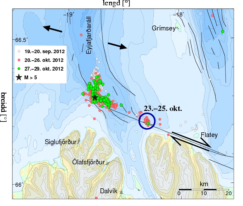

The earthquake swarm in the Tjörnes Fracture Zone north off Iceland continues into its 10th day. After a decline in intensity during 25-28 Oct, the frequency of quakes has again picked up. There are often more than 100 quakes a day including some above magnitude 3. The Icelandic Met Office maintains a warning for a possible larger quake in the area.
- All news about: Tjörnes Fracture Zone volcano
- Information about: Tjörnes Fracture Zone volcano

Experts from the National Seismological Network are keeping the volcano under surveillance. Courtesy of RSN
The Poas Volcano early Sunday awoke residents of the province of Alajuela with a strong rumble.
At about 1 a.m., the volcano’s crater ejected mud and ash more than 500 meters into the air. Ashes traveled hundreds of meters around the national park, rangers reported.
Although the volcano is frequently active, this kind of strong explosion has not been recorded since 2006. Experts said the activity was normal, but they will continue monitoring the volcano.
Poás Volcano National Park will remain open to tourists while experts determine if there is any risk to visitors.
***********************************************************************************************************
Extreme Temperatures/ Weather
Cold snap hits France with first signs of winter
Published on Oct 28, 2012 by Euronews
http://www.euronews.com/ “C’est l’hiver avant l’heure;” or ‘it is winter before it should be’, was one local person’s reaction to heavy snow falls which have hit eastern parts of France.
The cold snap brought power cuts with up to 50,000 households in the Isere region in the Alps deprived of electricity.
Authorities have issued an “Orange” warning, the second highest alert, and rescue services have been fully mobilised.
Up to 50 centimetres of snow fell in some parts making driving hazardous. An icy wind and fresh falls of snow on top of the ice only added to the dangerous conditions.
Many drivers were forced to abandon their cars while emergency services were called to clear trees from roads felled in the high winds, with gusts blowing up to 130 kilometres per hour recorded in one area.
Parts of the south of France were the worst hit by the high winds where on the riviera two people have been reported missing.
A search has been mounted for a 12-year-old boy on the island of Porquerolles. Emergency services say his bike has been found. A 26-year-old windsurfer is also missing.
In the port of Marseille the ferry Napoleon Bonaparte was damaged when strong winds broke the ship’s moorings.
The hull smashed against the dock flooding two of its watertight compartments.
Cold snap to sweep through China

Citizens wearing thick clothes walk on a street in Changchun, capital of northeast China’s Jilin Province, Oct. 28, 2012. A cold front swept the province on Sunday, lowering the temperature nine to 11 degrees centigrade in most parts of the province and bringing the lowest temperature down to less than zero.
Beijing — China’s central and eastern regions will experience temperature drops in coming days, while the southern parts will receive moderate to heavy rain, the national meteorological watchdog forecast Sunday.
Strong wind will make temperatures in northeastern regions fall by six to ten degrees Celsius on Sunday. A blast of cold air is forecast to sweep across the central and eastern parts from Monday, the National Meteorological Center said on its website.
The center also forecast that fog will shroud parts of Hubei, Jiangsu and Anhui provinces on Sunday morning, reducing visibility to less than 1,000 meters.
Over the next three days, parts of South China will see moderate to heavy rain, and some regions may experience torrential rain, the center said.
Son-Tinh, the 23rd tropical storm of the year, strengthened to a super-typhoon on Saturday night and was located 260 km southeast of Vietnam’s Thanh Hoa at 5 a.m. Sunday.
Son-Tinh is expected to move northwestward at a speed of 10 to 15 km per hour and make landfall in Vietnam’s northern coastal regions on Sunday night, the center said.
Sweden braces for week of heavy snow
Meteorologists predict heavy snowfall throughout the country and have issued a nationwide class 1 warning.
“There may be large quantities of snow,” explained Lisa Frost of the Swedish Meteorological and Hydrological Institute, SMHI.
“As it’s the first snow and it’s quite early in the season, we’re issuing the warning – especially as some people haven’t changed to their winter tyres yet.”
Throughout Monday, the Dalarna and Värmland counties have been slammed by a lengthy snow storm, which has left 10 cm (4 inches) of snow. SMHI forecast a further 10 cm before Tuesday.
Meanwhile, the Swedish Transport Administration (Trafikverket) is already fighting the blizzards.
The season’s lowest temperature was recorded on Sunday night with Nattavaara in far northern Sweden hitting -22.1C (-6F).
Surprise October snow hits central Germany – Suspected record
Winter appeared overnight in many parts of Germany on Saturday with unseasonal heavy snow fall and subzero temperatures hitting central and southern areas.
Meteorologists say this is the first time for decades that snow has fallen on low lying areas in October. More flurries are expected over the weekend.
As much as 17cm of snow fell overnight in Thuringen forest in central Germany – a suspected record for this time of year.
Heavy snow also fell on Bavaria, Saxony, Rhineland-Palatinate, Hesse and Saarland, with further flurries expected on Saturday in Leipzig, Dresden and Munich, according to the DWD.
“This happens maybe once every 30 or 40 years,” meteorologist Christoph Hartmann of the German weather service (DWD) told Die Welt newspaper on Saturday, referring to the unusual snowfall in October.
The severe drop in temperature – by 20 degrees within a week – also occurs “very, very seldom,” he added.
With winter’s first onslaught, fallen trees blocked train lines between Leipzig and Munich, causing delays and diversions to the ICE high speed rail network.
A further 10-15 cm of snow is expected overnight in the Alps and in the Ore Mountains in Saxony, where DWD said temperatures could fall as low as minus ten.
Austria – Rare October snow catches drivers by surprise
Only twice before since records began has there been snow in October in all the nine provinces of Austria, on the 31 October 1941 as well as in the night of 23 and 24 October 2003.
Austrian weather expert Alexander Orlik from the central weather institute ZAMG said: “It is true the snow is very early this year and that is an indication that it will be a long hard winter, but not proof.”
The early snow caught many drivers unaware who had not yet changed over to winter tyres – causing problems on the roads. The legal deadline to have winter tyres is 1 November in Austria.
In Carinthia parts of the region were left without electricity as the snow fell as a result of heavy snow meaning trees toppled onto the lines .
Early Snow Pummels West Virginia
By KRIS MAHER
Parts of West Virginia were digging out from up to three feet of snow dumped in the aftermath of Hurricane Sandy, a deluge that cut power to hundreds of thousands of residents and shut down main highways.
The thick blanket of snow at higher elevations across the ridges of the Appalachian Mountains, including in parts of Maryland and Pennsylvania, also brought concerns that rivers and creeks in low-lying areas could flood later in the week as the snow melts, with temperatures expected to reach 60 degrees. Falling trees and storm-related traffic accidents claimed the lives of three people in Maryland, three in Pennsylvania and one in West Virginia, state officials said Tuesday.
Close to 300,000 West Virginia residents were without power Tuesday afternoon, as high winds and heavy snow snapped branches and downed power lines, and officials expected the number to rise. Outages at several utilities had left some areas without access to water, and officials were sending out trucks to deliver bottled water.
“West Virginia continues to be hard hit,” said Gov. Earl Ray Tomblin, a Democrat. “Right now, my main focus is on life safety, power restoration and critical infrastructure.…We are doing everything we can to help the folks in need.”
More than 30 of West Virginia’s 55 counties had snow, with the heaviest snowfall at higher elevations, said Liz Sommerville, a National Weather Service meteorologist in Charleston, W.Va. Bowden, above 3,000 feet, recorded 24 inches by early Tuesday, compared with 16 inches in Beckley, elevation 2,300 feet, and 9 inches in the capital of Charleston, elevation 980 feet.
“Trees are coming down. I got a feeling that a lot of weaker structures are going to come down,” said Gary Berti, of Davis, W.Va., where 30 inches of snow had fallen by Tuesday afternoon. Mr. Berti, 54 years old, said all the stores along the main street of Davis were closed Tuesday and only pickup trucks with four-wheel drive were braving secondary roads. Restaurants without power were making food for rescue workers using gas stoves, he said: “They’re cooking everything they’ve got because they know they’re going to lose it.”
Snow was expected to keep falling on mountainous areas through Wednesday, and blizzard warnings remained in effect in more than a dozen counties Tuesday. At lower elevations, snow was expected to turn to rain by Tuesday night.
The West Virginia Department of Transportation reported accidents on three major highways in the state and said fallen trees and power lines were complicating efforts to clear roads. The agency urged residents to stay home. Marshall University canceled classes at various campuses around the state, and West Virginia State University closed for the day.
Western Maryland recorded two feet of snow, and blizzard warnings remained in effect Tuesday. While eastern areas of the state endured some flooding, officials were bracing for worse, said Ed McDonough, a spokesman for the Maryland Emergency Management Agency. More than 300,000 people in the state were without power Tuesday, with many outages in the Baltimore area. About 50 people were evacuated late Monday from the town of Crisfield, which sits on the Chesapeake Bay, after floodwaters spilled into homes.
Sandy’s Swath
- East Coast Grapples With Sandy’s Fallout
- New Jersey Sorts Through Wreckage
- Power Outages May Last Over a Week
- Industry Adapts Quickly to Storm
- Travelers Face Nightmare
- Storm Prompts Shifts in Voting Procedures
- Heroes Shine Amid Storm’s Destruction
- What Happens to All Those Swamped Cars?
- Sandy Exacts Toll on the Economy
- Questions Cloud Market Reopening
- Filing a Claim? Here’s What to Do
- New York Transit System Crippled by Floods
- 911 System Swamped
- Jason Gay: Forget Parades—This Is the Real New York City
- After Blaze, Breezy Point Bands Together
In Pennsylvania, 1.25 million residents remained without power Tuesday. Gov. Tom Corbett warned that the central part of the state could see minor flooding, but far less than what storms last year brought to the region. The highest point in the state, Mount Davis, received 9 inches of snow, with several more inches expected. There is “nothing of major significance at this point in time that we have great concern about,” Gov. Corbett said at a midday news briefing.
Pennsylvania officials planned to have a shelter open in West Chester, Pa., to house 1,300 people from New Jersey, and another in East Stroudsburg, Pa., to aid 500 people displaced in New York. In addition, Pennsylvania officials were providing 35 ambulances and a large vehicle to transport people, as well as providing a rescue team requested by the Federal Emergency Management Agency to New Jersey.
—Jennifer Corbett Dooren contributed to this article.
| 31.10.2012 | Extreme Weather | USA | State of Alaska, [Novarupta volcan] |  |
 |
Extreme Weather in USA on Wednesday, 31 October, 2012 at 19:24 (07:24 PM) UTC.
| Description | |
| Strong winds swept ash from the largest volcanic eruption of the 20th century into the atmosphere Tuesday, creating a haze over Alaska’s Kodiak Island and prompting the National Weather Service to issue flight warnings for the area. Powerful northwest winds funneled through the mountains at the Katmai Bay, sending ash around 4,000 feet into the sky southeast toward Kodiak. Brian Hagenbuch, general meteorologist at the National Weather Service Anchorage office, was the first to spot the ash. “When the sun came up yesterday, I noticed it looked foggy on the Larson Bay camera,” one of many cameras set up by the FAA to monitor weather conditions. But as the sun continued to rise, he noted the fog looked smoggy and brown. Around 10 a.m., Hagenbuch checked the visible satellite and found a “milky, dome-shaped plume.” He then double-checked on infra-red equipment that is used specifically to spot ash even through cloud cover, which verified his findings. Having confirmed his suspicions, Hagenbuch put together a “Significant Meterological Event” warning, called a SIGMET, to alert pilots of the hazardous conditions in the area. Hagenbuch says that very strong winds “from time to time” will stir up the ash from Novarupta. The Novarupta volcanic eruption of June 6, 1912, occurred in what is now the Katmai National Park and Preserve. For three days, the volcano spewed 100 times more material than the Mount St. Helens eruption, shooting plumes 20 miles into the air and burying the valley downwind in over 500 feet of ash and volcanic rock. Four years later, when botanist Robert Griggs visited the valley, steam still poured from vents across the valley, prompting the crew to name it The Valley of Ten Thousand Smokes. Hagenbuch will update, and possibly cancel, the SIGMET on the National Weather Service’s website Wednesday. Hagenbuch notes that there is “much less” ash in the air than Tuesday. |
***********************************************************************************************************
Storms / Flooding / Landslides
| Active tropical storm system(s) | ||||||||||
| Name of storm system | Location | Formed | Last update | Last category | Course | Wind Speed | Gust | Wave | Source | Details |
| Rosa (EP17) | Pacific Ocean – East | 30.10.2012 | 31.10.2012 | Hurricane V | 275 ° | 743 km/h | 93 km/h | 2.44 m | NOAA NHC | |
Tropical Storm data
|
|||||||||||||||||||||||||||||||||||||||||||||||||||||||||||||||||||||||||||||||||||||||||||||||||||||||||||||||||||||||||||||||||
|
|||||||||||||||||||||||||||||||||||||||||||||||||||||||||||||||||||||||||||||||||||||||||||||||||||||||||||||||||||||||||||||||||
…………………………………….
Crew member dead, captain missing after Canadian-built replica of HMS Bounty sinks
Paul Koring and Jane Taber
The Globe and Mail
 |
Washington – One crew member has died and the captain is missing in high seas and raging winds after the Canadian-built replica of HMS Bounty was abandoned and sank Monday morning.
U.S. Coast Guard Jayhawk helicopters rescued 14 others from life rafts in a dramatic dawn rescue about 150 kilometres off Cape Hatteras, N.C.
As the crew abandoned the sinking ship, struggling to get into life rafts before dawn, three were tossed into the sea by waves sweeping over the stricken vessel. “One of those managed to get to a raft, but not the other two,” U.S. Coast Guard spokesman Lieutenant-Commander Jamie Frederick told The Globe and Mail at 13:30 pm.
The dead crew member, 42-year-old Claudene Christian, was found unresponsive in the water on Monday evening. The Coast Guard said she was taken to a hospital in Elizabeth City, where she was later pronounced dead.
Rescuers continued to search for the missing captain of HMS Bounty, 63-year-old Robin Walbridge.
The Coast Guard says Captain Walbridge and Ms. Christian were able to put on survival suits designed to keep them afloat and protect them from chilly waters for 15 hours.
Helicopters were used in the search and two Coast Guard cutters have also gone out to sea to help search.
“We’re throwing all the assets we have out there so that we can keep searching for these folks,” Cdmr Frederick said.
Earlier he confirmed that “14 are safe on shore.”
Storm damages crops in Haiti, fueling food price woes
Reuters
-
 © The Associated Press/Dieu Nalio Chery
Many homes remain underwater in southern Haiti.Huge crop losses in southern Haiti raise famine worries
- Flooding raises specter of cholera
- Crop losses in Cuba, Jamaica as well

Port-au-Prince – As Hurricane Sandy barreled toward the U.S. East Coast on Monday, the full extent of the storm’s havoc on Haiti was just beginning to emerge.
Extensive damage to crops throughout the southern third of the country, as well as the high potential for a spike in cases of cholera and other water-borne diseases, could mean Haiti will see the deadliest effects of Sandy in the coming days and weeks.
Haiti reported the highest death toll in the Caribbean, as swollen rivers and landslides claimed at least 52 lives, according to the country’s Civil Protection office. More than three days of constant rain left roads and bridges heavily damaged, cutting off access to several towns and a key border crossing with the Dominican Republic.
“The economy took a huge hit,” Prime Minister Laurent Lamothe told Reuters. He also said Sandy’s impact was devastating, “even by international standards,” adding that Haiti was planning an appeal for emergency aid.
“Most of the agricultural crops that were left from Hurricane Isaac were destroyed during Sandy,” he said, “so food security will be an issue.”
Sandy also destroyed banana crops in eastern Jamaica as well as decimating the coffee crop in eastern Cuba.
But the widespread loss of crops and supplies in the south, both for commercial growers and subsistence farmers, is what has Haitian authorities and aid organizations had worried about most.
The past several months have seen a series of nationwide protests and general strikes over the rising cost of living. Even before Hurricane Sandy hit, residents complained that food prices were too high.

Carmene Chales, left, walks with Anes Michaelange and one-year-old Alexandra Alexandre through an area where Hurricane Sandy triggered flooding in Port-au-Prince, Haiti, Saturday, Oct. 27, 2012.
Peasant Crop Losses
A rise in food prices in Haiti triggered violent demonstrations and political instability in April 2008. Jean Debalio Jean-Jacques, the Ministry of Agriculture’s director for the southern department, said he worried that the massive crop loss “could aggravate the situation.”
“The storm took everything away,” said Jean-Jacques. “Everything the peasants had in reserve – corn, tubers – all of it was devastated. Some people had already prepared their fields for winter crops and those were devastated.”
In Abricots on Haiti’s southwestern tip, the community was still recovering from the effects of 2010’s Hurricane Tomas and a recent dry spell when Sandy hit.
“We’ll have famine in the coming days,” said Abricots Mayor Kechner Toussaint. “It’s an agricultural disaster.”
The main staples of the local diet, bananas and breadfruit, were ripped out by winds and ruined by heavy rains.
In the southwestern Grand Anse department, a boat that regularly comes from Port-au-Prince to deliver supplies and pick up produce to sell in the capital had not come in more than a week because of the storm. The cost of basic things, like fuel, had already jumped.
In Camp-Perrin, a mountainous region in the southwest peninsula where Sandy’s first fatality was recorded after a woman tried to cross a swollen river, coffee planters lamented the loss of a harvest they were weeks away from collecting.
“Coffee is the bank account of the peasants,” said Maurice Jean-Louis, a planter and head of a coffee growers’ cooperative in Camp-Perrin. Rain flooded many storage areas as well, soaking coffee beans that were set aside for export. He called the damage “incalculable.”
Cholera in the Capital
In the capital, Port-au-Prince, Sandy destroyed concrete homes and tent camps alike, where 370,000 victims of the 2010 earthquake are still living. Haitian authorities said 18,000 families were left homeless in the disaster.
Aid organizations began reporting a sharp rise in suspected cholera cases in several departments, with at least 86 new cases alone coming from Port-au-Prince’s earthquake survivor camps, according to Dr. Juan Carlos Gustavo Alonso of the Pan American Health Organization. Many communities are still cut off and only accessible by helicopter, he said, so the broader rise in cholera was “still too early to tell.”
Since October 2010, a cholera outbreak has sickened almost 600,000 people and killed more than 7,400 in Haiti.
Both the Haitian state and international aid organizations distributed food, water and other items to affected camps and communities throughout the weekend, including personal distributions by President Michel Martelly.
“These stocks are running dangerously low,” said George Ngwa, spokesman for OCHA, a humanitarian coordinating body in Haiti. “After Tropical Storm Isaac in August, these stocks have not been replenished. What we’re doing is scraping the bottom.”
Powerful storm kills at least 30 in Philippines, Vietnam
 Boats sit in the Beilun River, which separates China and Vietnam, on Tuesday, October 30. Tropical Storm Son-Tinh was moving northeast along the northern Vietnamese coast on Monday after tearing the roofs off hundreds of houses and breaching flood defenses overnight, the state-run Vietnam News Agency reported.

 An uprooted tree crushes a car in China on Sunday.
- More than a thousand rescue workers have been deployed in Vietnam
- Helicopters are on standby to search for an oil rig adrift from its towboats
- Tropical Storm Son-Tinh had already killed at least 27 people in the Philippines
Hong Kong (CNN) — As Hurricane Sandy lashes the East Coast of the United States with wind and rain, Southeast Asia is dealing with the trail of death and damage from a powerful storm that has killed at least 30 people in the region over the past few days.
Superstorm Sandy threatens ‘catastrophe’ of a lifetime
Tropical Storm Son-Tinh was moving northeast along the northern Vietnamese coast on Monday after tearing the roofs off hundreds of houses and breaching flood defenses overnight, the state-run Vietnam News Agency (VNA) reported.
Son-Tinh was at typhoon level when it thumped into northern Vietnam late Sunday with winds as strong as 133 kilometers per hour (83 mph). It left three people dead and two injured, according to an initial estimate from the Office of the National Search and Rescue Committee reported by (VNA).
More than a 1,300 rescue workers and soldiers have been deployed to work with local authorities on search and rescue efforts in the aftermath of the storm, VNA said.
Helicopters were on standby for a search and rescue mission for an oil rig with 35 people on board that became disconnected from its towboats miles out at sea amid strong waves generated by the storm, according to VNA.
And five people were missing Sunday after winds from Son-Tinh sank an engineering vessel near a cargo terminal in Sanya, a city on the southern Chinese island of Hainan, China’s state-run news agency Xinhua reported.
Son-Tinh is expected to gradually weaken over the course of Monday, regional weather agencies said. At least 260,000 people in Vietnam had been relocated to safer areas as it approached Sunday.
The storm had already killed 27 people when it swept across the central Philippines during the second half of last week, causing flash floods and landslides, according to the Philippine National Disaster Risk Reduction and Management Council. Nine people remain missing, the council said Monday.
East Asia is buffeted for several months a year by heavy storms that roll in from the western Pacific Ocean. In August, a big typhoon, named Bolaven, killed more than 60 people on the Korean peninsula.
Storm Barrels Through Region, Leaving Destructive Path
-
![]()
Brendan Smialowski/Agence France-Presse — Getty Images
-
![]()
Mark Lennihan/Associated Press
-
![]()
Hiroko Masuike/The New York Times
-
![]()
Damon Winter/The New York Times
-
![]()
Chang W. Lee/The New York Times
-
![]()
Fred R. Conrad/The New York Times
-
![]()
Hiroko Masuike/The New York Times
-
![]()
Justin Lane/European Pressphoto Agency
-
![]()
Kirsten Luce for The New York Times.
-
![]()
Frank Franklin Ii/Associated Press
-
![]()
Suzanne DeChillo/The New York Times
-
![]()
Michael Kirby Smith for The New York Times
-
![]()
Michael Kirby Smith for The New York Times
-
![]()
Michael Kirby Smith for The New York Times
-
![]()
Spencer Platt/Getty Images
-
![]()
Hiroko Masuike/The New York Times
-
![]()
Hiroko Masuike/The New York Times
-
![]()
Marcus Yam for The New York Times
-
![]()
Charles Sykes/Associated Press
-
![]()
Michael Nagle for The New York Times


The mammoth and merciless storm made landfall near Atlantic City around 8 p.m., with maximum sustained winds of about 80 miles per hour, the National Hurricane Center said. That was shortly after the center had reclassified the storm as a post-tropical cyclone, a scientific renaming that had no bearing on the powerful winds, driving rains and life-threatening storm surge expected to accompany its push onto land.
The storm had unexpectedly picked up speed as it roared over the Atlantic Ocean on a slate-gray day and went on to paralyze life for millions of people in more than a half-dozen states, with extensive evacuations that turned shorefront neighborhoods into ghost towns. Even the superintendent of the Statue of Liberty left to ride out the storm at his mother’s house in New Jersey; he said the statue itself was “high and dry,” but his house in the shadow of the torch was not.
The wind-driven rain lashed sea walls and protective barriers in places like Atlantic City, where the Boardwalk was damaged as water forced its way inland. Foam was spitting, and the sand gave in to the waves along the beach at Sandy Hook, N.J., at the entrance to New York Harbor. Water was thigh-high on the streets in Sea Bright, N.J., a three-mile sand-sliver of a town where the ocean joined the Shrewsbury River.
“It’s the worst I’ve seen,” said David Arnold, watching the storm from his longtime home in Long Branch, N.J. “The ocean is in the road, there are trees down everywhere. I’ve never seen it this bad.”
In New York, Gov. Andrew M. Cuomo’s office said late Monday night that at least five deaths in the state were attributable to the storm. At least three of those involved falling trees. About 7 p.m., a tree fell on a house in Queens, killing a 30-year-old man, the city police said. About the same time, two boys, ages 11 and 13, were killed in North Salem in Westchester County, when a tree fell on the house they were in, according to the State Police.
In Morris County, N.J., a man and a woman were killed when a tree fell on their car Monday evening, The Associated Press reported.
In Manhattan, NYU Langone Medical Center’s backup power system failed Monday evening, forcing the evacuation of patients to other facilities.
In a Queens beach community, nearly 200 firefighters were battling a huge blaze early on Tuesday morning that tore through more than 50 tightly-packed homes in an area where heavy flooding slowed responders.
Earlier, a construction crane atop one of the tallest buildings in the city came loose and dangled 80 stories over West 57th Street, across the street from Carnegie Hall.
Soon power was going out and water was rushing in. Waves topped the sea wall in the financial district in Manhattan, sending cars floating downstream. West Street, along the western edge of Lower Manhattan, looked like a river. The Brooklyn-Battery Tunnel, known officially as the Hugh L. Carey Tunnel in memory of a former governor, flooded “from end to end,” the Metropolitan Transportation Authority said, hours after Gov. Andrew M. Cuomo of New York ordered it closed to traffic.Officials said water also seeped into seven subway tunnels under the East River.
Joseph J. Lhota, the transit authority chairman, called the storm the most devastating disaster in the 108-year history of the subway system.
“We could be fishing out our windows tomorrow,” said Garnett Wilcher, a barber who lives in the Hammells Houses, a block from the ocean in the Rockaways in Queens. Still, he said he felt safe at home. Pointing to neighboring apartment houses in the city-run housing project, he said, “We got these buildings for jetties.”
Hurricane-force winds extended up to 175 miles from the center of the storm; tropical-storm-force winds spread out 485 miles from the center. Forecasters said tropical-storm-force winds could stretch all the way north to Canada and all the way west to the Great Lakes. Snow was expected in some states.
Businesses and schools were closed; roads, bridges and tunnels were closed; and more than 13,000 airline flights were canceled. Even the Erie Canal was shut down.
Subways were shut down from Boston to Washington, as were Amtrak and the commuter rail lines. About 1,000 flights were canceled at each of the three major airports in the New York City area. Philadelphia International Airport had 1,200 canceled flights, according to FlightAware, a data provider in Houston. And late Monday night, Mayor Michael R. Bloomberg said cabs had been instructed to get off New York City roads.
A replica of the H.M.S. Bounty, a tall ship built for the 1962 movie “Mutiny on the Bounty” starring Marlon Brando and used in the recent “Pirates of the Caribbean” series, sank off the North Carolina coast. The Coast Guard said the 180-foot three-masted ship went down near the Outer Banks after being battered by 18-foot-high seas and thrashed by 40-m.p.h. winds. The body of one crew member, Claudene Christian, 42, was recovered. Another crew member remained missing.
Delaware banned cars and trucks from state roadways for other than “essential personnel.”
“The most important thing right now is for people to use common sense,” Gov. Jack Markell said. “We didn’t want people out on the road going to work and not being able to get home again.”
By early evening, the storm knocked out power to hundreds of thousands of homes, stores and office buildings. Consolidated Edison said that as of 1:30 a.m. Tuesday, 634,000 customers in New York City and Westchester County were without power. Con Edison, fearing damage to its electrical equipment, shut down power pre-emptively in sections of Lower Manhattan on Monday evening, and then, at 8:30 p.m., an unplanned failure, probably caused by flooding in substations, knocked out power to most of Manhattan below Midtown, about 250,000 customers. Later, an explosion at a Con Ed substation on East 14th Street knocked out power to another 250,000 customers.
In New Jersey, more than two million customers were without power as of 1:30 a.m. Tuesday, and in Connecticut nearly 500,000.
President Obama, who returned to the White House and met with top advisers, said Monday that the storm would disrupt the rhythms of daily life in the states it hit. “Transportation is going to be tied up for a long time,” he said, adding that besides flooding, there would probably be widespread power failures. He said utility companies had lined up crews to begin making repairs. But he cautioned that it could be slow going.
“The fact is, a lot of these emergency crews are not going to get into position to start restoring power until some of these winds die down,” the president said. He added, “That may take several days.”
Forecasters attributed the power of the storm to a convergence of weather systems. As the hurricane swirled north in the Atlantic and then pivoted toward land, a wintry storm was heading toward it from the west, and cold air was blowing south from the Arctic. The hurricane left more than 60 people dead in the Caribbean before it began crawling toward the Northeast.
“The days ahead are going to be very difficult, Gov. Martin O’Malley of Maryland said. “There will be people who die and are killed in this storm,” he said.
Alex Sosnowski, a senior meteorologist with AccuWeather, said potentially damaging winds would continue on Tuesday from Illinois to the Carolinas — and as far north as Maine — as the storm barreled toward the eastern Great Lakes.
Mr. Cuomo, who ordered many of the most heavily used bridges and tunnels in New York City closed, warned that the surge from Hurricane Sandy could go two feet higher than that associated with Tropical Storm Irene last year. The PATH system, buses and the Staten Island Ferry system were also suspended.
Mr. Lhota, the chairman of the Metropolitan Transportation Authority, has said he expected to restore at least some service about 12 hours after the storm ended. But possible flooding within the subway system could prevent a full-scale reopening.
The storm headed toward land with weather that was episodic: a strong gust of wind one minute, then mist. More wind. Thin sheets of rain dancing down the street. Then, for a moment, nothing. The sky lightened. Then another blast of rain. Then more wind.
The day brought a giddiness to schoolchildren who had the day off and to grown-ups who were fascinated by the rough, rising water. Some went surfing, discounting the danger. Felquin Piedra, 38, rode his Jet Ski from Queens to Lower Manhattan.
“I love the waves,” Mr. Piedra yelled from New York Harbor. “The water is warm. I’ve jumped in several times.”
But even when landfall was still hours away, there was no holding back the advance guard of the storm — fast-moving bands of rain and punishing winds.
It added up to devastation. Driving through places like Pompton Plains, N.J., late Monday afternoon was like an X-Games contest for drivers. They had to do tree-limb slaloms on side streets and gunned their engines anxiously as they passed wind funnels of leaves swirling on highways.
On City Island, off the Bronx mainland, Cheryl Brinker sprayed “Sandy Stay Away” on her boarded-up art studio, expanding a collage she started during Tropical Storm Irene last year. But by midafternoon, nearby Ditmars Street was under as much as five feet of water and Steve Van Wickler said the water had cracked the cement in his cellar. “It’s like a little river running in my basement,” he said. “There are cracks and leaks everywhere.”
In some places, caravans of power-company trucks traveled largely empty roads; Public Service Electric and Gas said that 600 line workers and 526 tree workers had arrived from across the country, but could not start the repairs and cleanup until the wind had subsided, perhaps not until Wednesday.
They will see a landscape that, in many places, was remade by the storm. In Montauk, at the end of Long Island, a 50-seat restaurant broke in half. Half of the building floated away and broke into pieces on the beach.
The 110-foot-tall lighthouse at Montauk Point — the oldest in the state, opened in 1796 — shuddered in the storm despite walls that are six feet thick at the base. The lighthouse keeper, Marge Winski, said she had never felt anything like that in 26 years on the job.
“I went up in tower and it was vibrating, it was shaking,” she said. “I got out of it real quick. I’ve been here through hurricanes, and nor’easters, but nothing this bad.”
Sandy kills dozens in U.S., millions left without power
With at least 50 people dead, transit crippled in New York City and millions of people along the U.S. East Coast struggling without electricity, communities face a daunting challenge of repairing the damage wrought by superstorm Sandy.
In New York, where 18 people were killed, Mayor Michael Bloomberg surveyed the destruction in the hardest-hit neighbourhoods Tuesday. He said he saw homes so utterly destroyed only “chimneys and foundations” were left.
But despite the daunting challenge of recovery efforts, Bloomberg said “New Yorkers are resilient.”
About a third of New York’s fleet of taxis were operating Tuesday, bus service was partially restored, and the New York Stock Exchange was expected to reopen Wednesday.
U.S. President Barack Obama declared New York and Long Island a “major” disaster area.
The declaration means federal funding is now available to residents of the hardest-hit areas, who awoke to a tragic aftermath of the deadly storm that slammed ashore in New Jersey on Monday evening.
New York had seen a four-metre surge of seawater crash ashore overnight, inundating the city’s tunnels and electrical systems and causing massive damage to the city’s famed subway. The storm left New York with no running trains, a vacated business district and entire neighbourhoods under water.
New York’s Metropolitan Transportation Authority said the subway system, which remains closed, had suffered the worst damage in its 108-year history.
As of midday Tuesday, Sandy’s sustained winds were already diminishing from the 130 km/h it was packing at landfall near Atlantic City, N.J. on Monday evening.
But forecasters warn the storm system will continue to affect a region stretching from the U.S. eastern seaboard north to Canada, and as far west as Wisconsin and Illinois, as it churns across Pennsylvania before veering into western New York state sometime Wednesday.
New Jersey Gov. Chris Christie gave a bleak update at a morning news conference Tuesday, saying seaside rail lines were washed away, and there was no safe place on the state’s barrier islands for him as large parts of the coast are still under water.
“We are in the midst of urban search and rescue. Our teams are moving as fast as they can,” Christie said. “The devastation on the Jersey Shore is some of the worst we’ve ever seen. The cost of the storm is incalculable at this point.”
The effects aren’t contained to America’s largest city. More than 7.4 million homes and businesses in an area that stretches from the Carolinas in the south to Ohio in the northeast are without power Tuesday. Tens of thousands were also without electricity in southern parts of Ontario and Quebec too, as Sandy carries its combination of rain and wind northwards.
In Canada, a Toronto woman was killed Monday evening after she was struck by a falling sign blown down in the powerful storm’s high winds.
Most of the Sandy-related wind warnings issued by Environment Canada have been called off however, except for the Sarnia region, areas along the St. Lawrence River in Quebec and Inverness County in Nova Scotia.
The storm was officially downgraded from hurricane status, but it came ashore packing a lot of energy due to its unusually low barometric pressure. Combined with a cold-weather system from the north, and the high tide of the full moon, the storm is forecast to continue wreaking havoc across a 1,300-kilometre region that’s home to 50 million people through Wednesday.
Forecasters are even warning as much as one metre of snow could fall in some states, some of which has already fallen in West Virginia and other higher ground inland.
Notable effects of post-tropical storm Sandy:
- U.S. death toll so far is 50, including 18 people in New York, and numerous others killed in a total of seven states.
- In Canada, one woman is dead after she was struck by debris from a wind-blown sign in the west-end of Toronto Monday evening.
- Sandy had already been blamed for 69 deaths when it tore through the Caribbean.
- Concerns during the peak of the storm prompted shutdowns at two nuclear plants in New York and New Jersey, as well as an alert at America’s oldest nuclear plant at Barneget Bay, N.J.
- 200 patients, including those on respirators and babies in intensive care, evacuated after New York University’s Tisch Hospital lost power.
- Winds toppled a construction crane atop a 74-storey luxury high-rise in midtown Manhattan, forcing the evacuation of nearby buildings.
- Fire destroyed at least 50 homes in the Breezy Point section of Queens.
- Four unoccupied row houses in Baltimore collapsed in the storm.
- Wind gusts of more than 100 km/h prompted the closure of the port in Portland, Maine.
- Flooding in areas from Virginia to Atlantic City, where the storm washed away a 15-metre section of the famous boardwalk. New York City’s now-flooded subway remains shut.
- The Holland Tunnel connecting New York to New Jersey is closed, as is a tunnel between Brooklyn and Manhattan. The Brooklyn Bridge, the George Washington Bridge, the Verrazano-Narrows Bridge is also barricaded due to high winds.
- More than 12,000 commercial flights are cancelled, with more expected. New York’s LaGuardia, Newark Liberty and Kennedy airports are all closed.
- One crew member of the Canadian-built HMS Bounty sunk in storm-battered seas off North Carolina was found and later pronounced dead. 14 others rescued alive, but the captain is still missing.
An estimated 360,000 residents of 30 Connecticut communities were under mandatory and voluntary evacuation orders.
While it could take days to determine the extent of the storm damage, early estimates peg the potential price tag anywhere between $10 billion and $20 billion, which could make it one of the costliest storms in U.S. history.
Ahead of Sandy making landfall Monday, U.S. President Barack Obama declared states of emergency in Massachusetts, Connecticut, Rhode Island, New York, New Jersey and Pennsylvania.
“Please listen to what your state and local officials are saying,” Obama said from the White House. “When they tell you to evacuate, you need to evacuate. Don’t delay, don’t pause, don’t question the instructions that are being given, because this is a powerful storm.”
On the U.S. presidential election front, both Obama and Republican presidential candidate Mitt Romney suspended campaigning Monday, with just a week left before voting day.
Cyclone Nilam spares Chennai
T. Ramakrishnan
-
 The Hindu Onlookers gather to get a glimpse of ‘Pratibha Cauvery’ that ran aground near Elliots Beach on Wednesday. Photo: V. Ganesan
 -
 The Hindu Cyclone ‘Nilam’ hits the Mamallapuram beach, in Chennai on Wednesday. Photo: B. Jothi Ramalingam
 -
 A bird’s eye view of Marina beach in Chennai on Wednesday. Nilam evoked fears of large-scale destruction among the people in coastal districts in north Tamil Nadu. Photo: PTI
 -
 The Hindu An aerial view of the cyclone Nilam ravaged Marina on Wednesday evening. Schools, colleges and other educational establishments have announced holiday for the third day on Thursday. Photo: S.R. Raghunathan
 -
 The Hindu A man takes cover from gusty winds at Anna Salai in Chennai on Wednesday. Photo: M. Vedhan
 -
![]()
-
 India Meteorological Department Image shows Cyclone Nilam as captured by Kalpana-1 satellite on Wednesday.


Storm makes landfall near Mamallapuram; rain claims four lives in Tamil Nadu
Cyclonic storm Nilam, which threatened to hit the Chennai coast, spared the city, but made landfall near Mamallapuram, about 60 km south of Chennai, on Wednesday evening.
Four persons were reported to have died during the day in different parts of the State, but a Revenue department official clarified that Kancheepuram district, where the storm crossed the coast between 4 p.m. and 5 p.m., did not report even a single death.
Nilam evoked fears of large-scale destruction among the people in coastal districts in north Tamil Nadu.
The exact details about the landfall would be known on Thursday after an assessment by the Meteorological Department, according to Y.E.A. Raj, Deputy Director General of Meteorology.
Though many areas in the northern belt received heavy rainfall on Tuesday night, the intensity was not much during the day when Nilam made the last leg of its journey. According to a bulletin issued on the basis of observations at 8-30 a.m., the storm lay centred about 260 km south southeast of Chennai, and by 6 p.m, it made landfall.
At the time of crossing the coast, Chennai recorded the maximum wind speed of 75 km per hour and Kalpakkam 65 km per hour. Hereafter, it was expected to weaken rapidly after making northwestward movement.
A holiday has been declared for schools and colleges in all coastal districts, including Chennai, on Thursday.
| Today | Tropical Storm | India | MultiStates, [States of Tamin Nadu and Andhra Pradesh] |  |
|
Tropical Storm in India on Thursday, 01 November, 2012 at 04:22 (04:22 AM) UTC.
| Description | |
| A tropical storm slammed into southern India, bringing heavy rain and a storm surge flooding low-lying areas and displacing more than 100,000 people. Just before the storm made landfall Wednesday, an oil tanker with 37 crew ran aground off Chennai. One of its lifeboats capsized in the choppy waters, and one crewmember drowned, the Press Trust of India news agency reported. Coast guard officers were searching for the lifeboat’s six other occupants. Andhra Pradesh state said two people died there when their homes collapsed due to heavy rain Wednesday night in Nellore and Chittoor districts, and PTI reported another death in Tamil Nadu state, a 46-year old man who slipped into the rough sea from a pier and drowned. Sri Lanka reported two deaths earlier from the cyclone. The storm from the Bay of Bengal had maximum winds of 75 kilometers (45 miles) per hour after landfall but was weakening. A storm surge of up to 1.5 meters (5 feet) was expected to flood low-lying coastal areas, the India Meteorological Department said. Heavy to very heavy rain was forecast for Thursday, and fishermen were asked to stay at shore. State authorities turned 282 schools into relief centers in Chennai, the capital of Tamil Nadu. The city’s port halted cargo operations, officials said. Twenty-three ships were moved to safer areas. About 150,000 people were moved to shelters in Nellore, district official B. Sridhar said. |
| Today | Tropical Storm | Sri Lanka | [Statewide] |  |
|
Tropical Storm in Sri Lanka on Thursday, 01 November, 2012 at 04:20 (04:20 AM) UTC.
| Description | |
| In Sri Lanka, thousands have been displaced due to heavy rain and strong winds. The nation’s Disaster Management Center said 4,627 people were displaced by flooding and 56 fled because of a landslide threat in the island’s central region. One woman died Tuesday after a tree branch fell on her, while another person was killed in flooding, the agency said. Floods also damaged about 1,000 houses, it said. |
| 01.11.2012 | Tropical Storm | USA | State of New York, New York City | |
|
Tropical Storm in USA on Tuesday, 30 October, 2012 at 03:43 (03:43 AM) UTC.
| Description | |
| Winds from hurricane Sandy have seriously damaged a building in Manhattan as the centre of the storm heads towards land. Part of the facade of a four story building in the West Village collapsed at about 6.30pm, leaving rooms open to the elements but no one injured. Elsewhere parts of midtown Manhattan were evacuated when a crane on top of a skyscraper partially collapsed. The Fire Department of New York initially reported a “multi-dwelling building collapse” on Twitter, although pictures quickly emerged showing that the front wall of the top two floors of the building was missing, rather than the entire structure collapsing. Images showed a fire truck at the scene, with a writer from the Huffington Post reporting that firefighters had to enter the building to help people out. The fire department later said that no one had been hurt. “There are no injuries or people trapped at 92 8th Ave building collapse, which involved the facade of the structure,” it said in a tweet. “Firefighters went in and rescued the residents. Some residents said same thing happened to same building 20 years ago,” said Meg Robertson, a reporter at HuffPost Live. She posted several pictures of the scene on her Twitter account. The building, 92 8th Avenue, is located between 14th and 15th streets in Manhattan. The main threat to buildings in New York City had been expected to come from flooding, with a mandatory evacuation order in place in many places along Manhattan’s coastline. Earlier a crane on top of the One 57 building, which is under construction on west 57th street further north in Manhattan, appeared to come loose from its bearings in high winds. Pictures showed the crane hanging upside down from the top of the building, which is set to be luxury flats. Police and the fire department evacuated all buildings north and south of 57th street, between Sixth and Seventh avenues, CNN reported. The Le Parker Meridien hotel on West 56th Street was also evacuated, according to reports, with guests being transferred to a different hotel. In New York bridges across the East River have been closed, including the Brooklyn, Manhattan and Williamsburg bridges, with people warned to stay inside. |
| Today | Landslide | Canada | Province of British Columbia, Langley [7700 block of 264th Street] | |
|
Landslide in Canada on Thursday, 01 November, 2012 at 04:36 (04:36 AM) UTC.
| Description | |
| City workers in Langley, B.C., are cleaning up after two mudslides stuck on Wednesday morning, forcing the evacuation of one home and the closure of 264th Street between 72nd and 84th avenues. Just after 5 a.m. PT, mud rushed down the side of a steep slope and crossed a rural stretch of the 7700 block of 264th Street, moving a cement barrier. The slide also covered the side of a home below the road. No one was injured and there was only minor damage to the house. About 100 metres of 264th Street has been closed for much of the morning. It’s not clear when the road might reopen. While officials were cleaning up the first slide, officials confirmed they were responding to reports of a second landslide in the municipality, this time at 252A Street and 72nd Avenue. The second slide was much smaller and did not affect any roads or homes, city officials said. City officials say small mudslides on the hills into Glen Valley are common this time of year. A rainfall warning is in effect in the area with between 10 and 20 millimetres expected to fall throughout the day. |
………………………………………………
National Data Buoy Center
10 Buoys in event mode
************************************************************************************************************
Radiation / Nuclear
LONGVIEW, Wash. (AP) — Oregon State University researchers have found traces of radioactive cesium from last year’s Japanese nuclear reactor disaster in West Coast albacore tuna.
The amount is far too small to harm people who eat the fish, the scientists said.
Scientists from the university and the National Oceanic and Atmospheric Administration collected and tested fish caught off the West Coast before and after the March 2011 Japanese earthquake and tsunami that caused a nuclear reactor to release radioactive material, the Longview Daily News (http://bit.ly/QIcdV8) reported.
The team’s findings are in line with work by researchers in California, who announced in May that they had found traces of radioactive cesium in bluefin tuna caught off the southern coast.
“We’re still processing new fish, but so far the radiation we’re detecting is far below the level of concern for human safety,” said Delvan Neville, a graduate researcher with OSU’s Radiation Health Physics program and a co-investigator on the project.
Albacore tuna is a $41 million business in the Pacific Northwest, and fishermen from the region caught about 10,000 tons last year, according to the U.S. Department of Commerce.
Washington fishermen accounted for about 53 percent of the haul, and the remainder came through Oregon docks.
The U.S. Environmental Protection Agency, Food and Drug Administration and NOAA have jointly stated they have “high confidence” in the safety of U.S. seafood products because the radiation levels are so low.
The OSU team said its findings could reveal information about where Pacific albacore tuna travel and how the ocean’s ecosystem can be linked to events thousands of miles away.
___
Information from: The Daily News, http://www.tdn.com
FACTBOX-U.S. nuclear units in the path of Hurricane Sandy
by Thomson Reuters
Oct 26 (Reuters) - U.S. electric companies from Maine to
Florida are preparing for heavy wind, rain and flooding that
could take down power lines and could close some East Coast
nuclear plants early next week when Hurricane Sandy comes
ashore.
    There are more than a dozen nuclear plants near Hurricane
Sandy's path in North Carolina, Virginia, Maryland, New Jersey,
Pennsylvania, New York and Connecticut, providing power to
millions of customers in the region.
    The following lists the nuclear reactors and utilities in
Sandy's potential path.

 Plant                 State              Size    Company
                                          (MW)

 Brunswick             North Carolina     1,858   Duke

 Surry                 Virginia           1,638   Dominion

 North Anna            Virginia           1,863   Dominion

 Calvert Cliffs        Maryland           1,705   Constellation

 Salem                 New Jersey         2,332   PSEG

 Hope Creek            New Jersey         1,161   PSEG

 Peach Bottom          Pennsylvania       2,244   Exelon

 Limerick              Pennsylvania       2,264   Exelon

 Three Mile Island     Pennsylvania        805    Exelon

 Susquehanna           Pennsylavnia       2,450   PPL

 Oyster Creek          New Jersey          615    Exelon

 Indian Point          New York           2,063   Entergy

 Millstone             Connecticut        2,102   Dominion

 Pilgrim               Massachusetts       685    Entergy

 Seabrook              New Hampshire      1,247   NextEra

 Vermont Yankee        Vermont             620    Entergy

 (Reporting By Scott DiSavino; Editing by Bob Burgdorfer)
By Christine Harvey
Nuclear reactors in the mid-Atlantic and Northeast are being monitored for potential impacts by Hurricane Sandy, a Category 1 storm that may strike anywhere from Delaware to southern New England.
“Because of the size of it, we could see an impact to coastal and inland plants,” Neil Sheehan, a spokesman based in King of Prussia, Pennsylvania, for the U.S. Nuclear Regulatory Commission, said by phone. “We will station inspectors at the sites if we know they could be directly impacted.”

Men walk amid the destruction caused by hurricane Sandy east of Havana in Mayari, Cuba. Source: AFP/Getty Images
The NRC met earlier today to discuss the necessary precautions to take for the storm, Sheehan said. Plants must begin to shut if wind speeds exceed certain limits, he said.
As of 2 p.m. New York time, Sandy had winds of 75 miles (121 kilometers) per hour, according to the National Hurricane Center in Miami. It was about 430 miles south-southeast of Charleston, South Carolina, moving north at 7 mph.
The current Hurricane Center track calls for the system to come ashore just south of Delaware Bay on Oct. 30.
Contingency Plans
Nuclear plants in the projected path of the hurricane include North Anna and Surry in Virginia, Calvert Cliffs in Maryland, Hope Creek and Salem in New Jersey, Indian Point in New York and Millstone in Connecticut. The NRC is considering enhancing inspector coverage of these reactors, Sheehan said in an e-mail today.
Public Service Enterprise Group Inc. (PEG) must shut all units at the Salem and Hope Creek plants two hours before the onset of hurricane-force winds greater than 74 mph, according to Sheehan. An “unusual event” would be declared if the winds are sustained for greater than 15 minutes or if the water level reaches 99.5 feet or higher, he said. Such an event is the lowest of four level of emergency used by the commission.
Salem Unit 2 is currently shut for refueling, while Unit 1 was operating at 83 percent of capacity today during maintenance on the circulating water system. Hope Creek ran at full power. The three units have a combined capacity of 3,365 megawatts.
“We are in phase one of our severe-weather plan,” Joe Delmar, a company spokesman, said in an e-mail responding to questions. “This includes inspecting, removing and securing outside areas for potential missiles, objects that could go airborne, and staging of emergency equipment and supplies.”
Millstone Reactor
Nuclear generation in the Northeastern region dropped 1.1 percent to 18,016 megawatts, with seven plants shut, an NRC report today showed.
Dominion Resources Inc.’s Millstone plant is monitoring Sandy’s progress and preparing to adjust staff as it comes closer, according to Ken Holt, a plant spokesman based in Richmond, Virginia. The plant must shut if winds reach 90 mph.
“We would shut down in advance of the storm if they were expected to be 90 miles per hour at the site,” Holt said by phone today. “Floods and high winds are a threat because they can knock off off-site power and we’d then need to activate emergency generators for power to put the plant to safe conditions.”
| Today | Nuclear Event | USA | State of Minnesota, Red Wing [Prairie Island Nuclear Power Plant] | |
|
Nuclear Event in USA on Thursday, 01 November, 2012 at 04:05 (04:05 AM) UTC.
| Description | |
| Xcel Energy Inc. says its Prairie Island nuclear plant near Red Wing declared an “unusual event” after some security equipment failed. The Minneapolis-based utility says the event happened around 2:15 p.m. Wednesday and was declared over just before 6 p.m. Xcel says there was no release of radioactive material and that there is no danger to the public or plant employees. Plant officials made the declaration after some security equipment temporarily failed. The equipment has been restored, and plant officials are investigating the cause. The plant maintained security during the event. Xcel says it notified federal, state and local officials. The declaration is the lowest of four emergency classifications. Prairie Island’s Unit 2 continues to operate at full power. Unit 1 remains offline has part of a scheduled refueling outage. |
************************************************************************************************************
Epidemic Hazards / Diseases
| 01.11.2012 | Epidemic Hazard | Uganda | Western Uganda, [Kabale District] | |
|
Epidemic Hazard in Uganda on Friday, 19 October, 2012 at 10:56 (10:56 AM) UTC.
| Updated: | Wednesday, 31 October, 2012 at 17:33 UTC |
| Description | |
| The death toll of the deadly Marburg hemorrhagic fever in Uganda has risen to eight and nine other people have tested positive of the highly infectious diseases, a top ministry of health official said. Christine Ondoa, Minister of Health told reporters on Monday that the latest patient died on October 27 at an isolation ward at Rushoroza Health Centre, in the western Ugandan district of Kabale, the epicenter of the outbreak. The disease broke out on October 4 in Kabale. Five people have tested positive of the highly infectious viral hemorrhagic fever in Kabale, two others in the capital Kampala and another two in the western district of Ibanda. “To date, the death toll of both the probable and confirmed cases stands at eight. Since the onset of the outbreak, we have collected a total of 45 samples of which nine were confirmed positive,” said Ondoa. She said the ministry has established temporary isolation facilities in Kabale, Mbarara, Ibanda and Kampala to accommodate the suspected and confirmed cases. “We have assembled a team of experts to work in the newly established isolation facilities and they are expected in these districts today. We also plan to undertake infection control procedures in these facilities as safety measures for the workers and the admitted patients,” said Ondoa. A total of seven student nurses who attended to a Marburg patient at Ibanda Hospital and died on October 24 at Mbarara Regional Hospital have been quarantined. The ministry is also monitoring a total 436 people who had contact with the patients. “Those being monitored got into contact with either the dead or confirmed cases. The team continues to monitor them on a daily basis for possible signs and symptoms of this highly infectious disease until they have completed 21 days without showing any signs and symptoms,”Ondoa said. | |
Epidemic Hazard in Uganda on Friday, 19 October, 2012 at 10:56 (10:56 AM) UTC.
| Updated: | Thursday, 01 November, 2012 at 04:38 UTC |
| Description | |
| As of the end of October, 18 cases and nine deaths have been reported as a result of Marburg hemorrhagic fever outbreak, according to WHO. The outbreak began in mid-October, and cases have been reported from five districts in southwestern Uganda, Kampala, Ibanda, Mbarara and Kabarole, with a case fatality rate of 50%. Blood samples from nine patients have been confirmed for Marburg virus at the Uganda Virus Research Institute. Currently, 13 patients have been admitted to the hospital, and their contacts are listed for daily follow-up. The latest confirmed case was admitted to an Ibanda district isolation ward on Oct. 26. The WHO and international partners, including the CDC, the Uganda Red Cross, African Field Epidemiology Network and Médecins-Sans-Frontières, are supporting the national authorities in outbreak investigation and response. The national task force has identified additional health care workers and epidemiologists to strengthen the teams in the field. Training of health workers on infection prevention and control, surveillance and clinical case management is ongoing, and the first shipment of personal protective equipment arrived recently. WHO and its partners have deployed additional staff to support the response teams. As the investigation into the outbreak continues, WHO and partners continue to support the national authorities as needed in the areas of coordination, infection prevention and control, surveillance, epidemiology, public information and social mobilization, anthropological analysis and logistics for outbreak response. Neighboring countries have been contacted to strengthen cross-border surveillance and preparedness to prevent cross border spread of the outbreak. | |
| Today | Epidemic Hazard | USA | State of California, [San Quentin State Prison, Marin County] | |
|
Epidemic Hazard in USA on Thursday, 01 November, 2012 at 04:40 (04:40 AM) UTC.
| Description | |
| Officials at San Quentin State Prison say the prison is on a medical lockdown after at least two inmates became sick with chickenpox. Prison spokesman Lt. Sam Robinson says the prison has been locked down since last Friday, with only employees being allowed to enter and leave the facility. He could not say when the lockdown would be lifted. Robinson says the last time there was a medical lockdown at the prison was in March of last year when at least four inmates became sick with chickenpox. The Centers for Disease Control describes chickenpox as a “very contagious disease” that spreads easily from infected people to others who have never had chickenpox or have never received the chickenpox vaccine. San Quentin, located north of San Francisco, is the oldest prison in California. It houses about 3,800 inmates. | |
| Biohazard name: | Chicken Pox |
| Biohazard level: | 2/4 Medium |
| Biohazard desc.: | Bacteria and viruses that cause only mild disease to humans, or are difficult to contract via aerosol in a lab setting, such as hepatitis A, B, and C, influenza A, Lyme disease, salmonella, mumps, measles, scrapie, dengue fever, and HIV. “Routine diagnostic work with clinical specimens can be done safely at Biosafety Level 2, using Biosafety Level 2 practices and procedures. Research work (including co-cultivation, virus replication studies, or manipulations involving concentrated virus) can be done in a BSL-2 (P2) facility, using BSL-3 practices and procedures. Virus production activities, including virus concentrations, require a BSL-3 (P3) facility and use of BSL-3 practices and procedures”, see Recommended Biosafety Levels for Infectious Agents. |
| Symptoms: | |
| Status: | confirmed |
| 31.10.2012 | Epidemic | Sudan | State of South Darfur, [Region-wide] | |
|
Epidemic in Sudan on Wednesday, 31 October, 2012 at 04:13 (04:13 AM) UTC.
| Description | |
| A previously unknown disease which has claimed more than 30 lives in Sudan’s troubled Darfur region this month has been identified as yellow fever, the World Health Organization (WHO) said on Tuesday. Preparations for a mass vaccination campaign are now underway. The outbreak was first detected early this month when a number of people in the central and southern regions of Darfur became ill and eventually died. Sudanese media said the victims suffered from a number of symptoms, including diarrhea, vomiting, and bleeding from both the mouth and nose. Tarik Jasarevic, a spokesman for the World Health Organization (WHO), on Tuesday said it had been informed by Sudan’s Federal Ministry of Health (FMoH) that the outbreak is being caused by yellow fever. Since the first week of October, a total of 84 suspected cases, including 32 deaths, have been reported in the districts of Azoom, Kass, Mershing, Nertiti, Nyala, Wadi Salih and Zalingei. “FMoH said that the immediate priority is to control the vector, reinforcing the disease surveillance system and raising public awareness on the prevention and control of this disease,” Jasarevic said. “Preparations for a mass vaccination campaign are underway to vaccinate the at risk population in Darfur.”According to Darfur radio station Dabanga, however, at least 37 people are believed to have died as a result of the disease while 125 others have been infected. The radio station quoted a resident as saying that local authorities were slow to react and did not immediately take necessary action to contain the outbreak. “FMoH, WHO, as well as health partners are working on ground to ensure timely containment of the outbreak,” Jasarevic added. There is no cure for yellow fever, which is an acute viral haemorrhagic disease transmitted by infected mosquitoes. Treatment is aimed at reducing the symptoms for the comfort of patients, and measures often taken include supportive care to treat dehydration and fever and blood transfusion if needed. “It is a preventable disease with symptoms and severity varying from case to case,” Jasarevic explained. “Protective measures like the use of bed nets, insect repellent and long clothing are considered the best methods to contain an outbreak. Vaccination is the single most important measure for preventing yellow fever.” | |
| Biohazard name: | Yellow Fever |
| Biohazard level: | 2/4 Medium |
| Biohazard desc.: | Bacteria and viruses that cause only mild disease to humans, or are difficult to contract via aerosol in a lab setting, such as hepatitis A, B, and C, influenza A, Lyme disease, salmonella, mumps, measles, scrapie, dengue fever, and HIV. “Routine diagnostic work with clinical specimens can be done safely at Biosafety Level 2, using Biosafety Level 2 practices and procedures. Research work (including co-cultivation, virus replication studies, or manipulations involving concentrated virus) can be done in a BSL-2 (P2) facility, using BSL-3 practices and procedures. Virus production activities, including virus concentrations, require a BSL-3 (P3) facility and use of BSL-3 practices and procedures”, see Recommended Biosafety Levels for Infectious Agents. |
| Symptoms: | |
| Status: | confirmed |
|
|
|
************************************************************************************************************
Space
| 01.11.2012 | Event into space | USA | State of California, Novato | |
|
Event into space in USA on Monday, 22 October, 2012 at 09:50 (09:50 AM) UTC.
| Updated: | Thursday, 01 November, 2012 at 04:36 UTC |
| Description | |
| A magnetic piece of rock stirred up controversy last week, but scientists confirmed, and reconfirmed, that the mysterious object in Novato residents Lisa and Kurt Webberâs backyard was a meteorite. And to prove it, a second was discovered just miles from the Webbersâ home. Webber gave the meteorite to her neighbor Glenn Rivera as a birthday gift. He helped her analyze the chunk before calling scientists. The meteorite broke off from the meteor shower that blazed over the night sky at approximately 7:44 p.m. on Oct. 17. It also happened to be Riveraâs birthday. âAs a result, Glenn was asked by the scientific team to ride in the airship Eureka from Moffett Field on Friday,â said Leigh Blair, Riveraâs mother. âThey flew over Novato and all the way up to Lake Berryessa, following the calculated trajectory of the meteor, looking for signs of larger meteorites on the ground.â Peter Jenniskens, the meteor scientist at the Seti Institute, a nonprofit scientific and education organization that has projects sponsored by NASA and other foundations and research groups, at first dismissed the first rock because the surface appeared strange and weathered, unlike most meteorites. But everything changed when a second rock showed small specks of what seemed to be metal, when observed under a microscope. Brien Cook, a meteorite hunter and Sacramento resident, found the second rock in the Novato area, but too dismissed it as a meteorite until the two chunks were compared. After cutting it open and looking inside, he knew he had found an extraterrestrial treasure. Cook is offering one chip of his meteorite on eBay. It weighs 6.6 grams, and objects like it regularly sell for approximately $100 a gram, he said. Lisa Webber, a University of California San Francisco nurse, found the meteorite in her backyard on Oct. 20. She returned the piece to Jenniskens, and he will send samples of both rocks to a noted meteorite expert Professor Alan E. Rubin of the Institute of Geophysics and Planetary Physics at UCLA. | |
Earth approaching objects (objects that are known in the next 30 days) |
|||||||||
| Object Name | Apporach Date | Left | AU Distance | LD Distance | Estimated Diameter* | Relative Velocity | |||
| 214869 (2007 PA8) | 05th November 2012 | 4 day(s) | 0.0433 | 16.8 | 1.5 km – 3.3 km | 10.79 km/s | 38844 km/h | ||
| (2011 UG21) | 06th November 2012 | 5 day(s) | 0.1784 | 69.4 | 340 m – 760 m | 19.73 km/s | 71028 km/h | ||
| (2010 WT) | 07th November 2012 | 6 day(s) | 0.1251 | 48.7 | 53 m – 120 m | 6.53 km/s | 23508 km/h | ||
| 333358 (2001 WN1) | 09th November 2012 | 8 day(s) | 0.1285 | 50.0 | 370 m – 830 m | 8.73 km/s | 31428 km/h | ||
| 330233 (2006 KV86) | 11th November 2012 | 10 day(s) | 0.1876 | 73.0 | 450 m – 1.0 km | 23.35 km/s | 84060 km/h | ||
| (2008 LH2) | 12th November 2012 | 11 day(s) | 0.1487 | 57.9 | 35 m – 78 m | 5.10 km/s | 18360 km/h | ||
| (2001 YM2) | 12th November 2012 | 11 day(s) | 0.0860 | 33.5 | 440 m – 980 m | 9.26 km/s | 33336 km/h | ||
| (2012 KF25) | 15th November 2012 | 14 day(s) | 0.1528 | 59.5 | 23 m – 51 m | 9.75 km/s | 35100 km/h | ||
| (1999 SF10) | 19th November 2012 | 18 day(s) | 0.0346 | 13.5 | 41 m – 92 m | 4.08 km/s | 14688 km/h | ||
| (2009 WB105) | 24th November 2012 | 23 day(s) | 0.0400 | 15.6 | 59 m – 130 m | 18.86 km/s | 67896 km/h | ||
| (2007 VB188) | 25th November 2012 | 24 day(s) | 0.1446 | 56.3 | 14 m – 32 m | 10.32 km/s | 37152 km/h | ||
| (1994 XD) | 27th November 2012 | 26 day(s) | 0.0518 | 20.2 | 400 m – 890 m | 20.03 km/s | 72108 km/h | ||
| (2009 LS) | 28th November 2012 | 27 day(s) | 0.1418 | 55.2 | 670 m – 1.5 km | 25.88 km/s | 93168 km/h | ||
| (2010 VW98) | 29th November 2012 | 28 day(s) | 0.1321 | 51.4 | 81 m – 180 m | 7.03 km/s | 25308 km/h | ||
| (2009 XH8) | 30th November 2012 | 29 day(s) | 0.1288 | 50.1 | 61 m – 140 m | 6.70 km/s | 24120 km/h | ||
|
|||||||||
*************************************************************************************************************
Biological Hazards / Wildlife / Environmental pollution / Hazmat
| Today | Biological Hazard | USA | State of Arizona, Phoenix [40000 block of W. Magnolia Road] | |
|
Biological Hazard in USA on Thursday, 01 November, 2012 at 04:18 (04:18 AM) UTC.
| Description | |
| Two men were transported to the hospital Wednesday afternoon after a bees’ nest was disturbed when one of the men, an unidentified DirectTV employee, was working on a home in the 40000 block of W. Magnolia Road. “It was terrible,” Phoebe Lechuga, one of the home’s five residents, said. “They were flying everywhere.” Lechuga’s 33-year-old son, Resugio Furwilder, was also transported to the hospital. Furwilder went outside to help the DirectTV worker and was stung himself, Lechuga said. Her daughter, Vanessa Lechuga, 27, was also stung but was not taken to the hospital. Lechuga said at first the worker thought there were only a few bees and didn’t come inside after the first stings. | |
| Biohazard name: | Bees Attack (Non-Fatal) |
| Biohazard level: | 0/4 — |
| Biohazard desc.: | This does not included biological hazard category. |
| Symptoms: | |
| Status: | |
| Today | Environment Pollution | USA | State of New Jersey, Woodbridge | |
|
Environment Pollution in USA on Thursday, 01 November, 2012 at 04:03 (04:03 AM) UTC.
| Description | |
| New Jersey environmental officials say 336,000 gallons of diesel fuel spilled after a storage tank was lifted and ruptured from the surge from superstorm Sandy. The Coast Guard says all the spilled oil is believed to be contained by booms put in the water. Officials said today the spill happened Monday night at the Motiva oil tank facility in Woodbridge. Coast Guard spokesman Les Tippets says a secondary tank caught most of the oil and that the liquid that escaped moved into the Arthur Kill, the waterway separating New Jersey from New York’s Staten Island. New Jersey Department of Environmental Protection spokesman Larry Ragonese says the company reported the spill and hired contractors to clean it up. |
| Today | HAZMAT | USA | State of Maryland, Baltimore | |
|
HAZMAT in USA on Thursday, 01 November, 2012 at 03:53 (03:53 AM) UTC.
| Description | |
| Three people from North Laurel, Maryland have been taken to the hospital Tuesday morning with carbon monoxide poisoning, caused by a generator running inside their house. Authorities reported that Howard County Fire crews and paramedics found a man and two women inside the home in Brevard Street after responding to a 911 call which was made by one of the women. The victims suffered elevated levels of carbon monoxide. According to a spokesman from the Howard County Department of Fire and Rescue Services, the three were transported to the University of Maryland Shock Trauma Center in Baltimore. The two females have been released on Tuesday morning but the male, who was in critical condition, remained in the hospital for further treatment. The spokesman confirmed that all three patients underwent therapy in the hyperbaric chamber at the University of Maryland Shock Trauma Center. The male patient is scheduled to receive another hyperbaric therapy. Police said the firefighters discovered a generator operating at the bottom of the stairs on the ground level of the residence. It was placed in a doorway leading to the garage, but the garage door was closed, restricting ventilation. Firefighters later confirmed that the amount of carbon monoxide inside the house was 30 times more than the normal level. |
| 01.11.2012 | HAZMAT | USA | State of Kentucky, Louisville [Near the Dixie Highway] | |
|
HAZMAT in USA on Monday, 29 October, 2012 at 21:24 (09:24 PM) UTC.
| Description | |
| Emergency officials have evacuated a few dozen homes near a derailed train in southern Jefferson County over concerns of hazardous material leaks. The Paducah & Louisville Railway train derailed just after 6 a.m. EDT Monday near Dixie Highway. Emergency officials are asking residents within a 2 ½-mile radius of the scene to stay inside their homes until they are told they can leave. Beuchel Fire assistant chief Rick Harrison says the train has a “small leak” of butadiene, which is a chemical used in the manufacturing of rubber. No other leaks have been found. Tom Garrett, president of P&L Railway, says the train was on its way to Louisville from Paducah with a total of 57 cars. He says company officials have not yet been able to get to the scene because of safety concerns. Garrett says the two crew members on the train were not hurt. Officials say eight of the 40 cars on the train were off the track. |
**************************************************************************************************************
Articles of Interest
Amazing Roll Cloud over Andrews, Texas
Sott.net


*************************************************************************************************************
[In accordance with Title 17 U.S.C. Section 107, this material is distributed without profit, for research and/or educational purposes. This constitutes ‘FAIR USE’ of any such copyrighted material.]


